جزیرہ ایسٹر
جزیرہ ایسٹر (easter island) (ہسپانوی: Isla de Pascua) جنوب مشرقی بحر اوقیانوس میں ایک پولینیشی جزیرہ ہے۔
جزیرہ ایسٹر Rapa Nui Isla de Pascua | |||||
|---|---|---|---|---|---|
| |||||
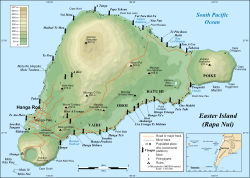 Easter Island map showing Terevaka, Poike, Rano Kau, Motu Nui, Orongo, and Mataveri; major ahus are marked with موائی | |||||
| دار الحکومت | ہانگا روا | ||||
| دفتری زبانیں | None. Spanish and راپا نوی زبان widely used. | ||||
| نسلی گروہ (2002) | Rapanui 60%, European or mestizo 39%, Amerindian 1% | ||||
| نام آبادی | جزیرہ ایسٹر or Pascuense | ||||
| حکومت | Special territory of Chile[1] | ||||
• Provincial Governor | Carmen Cardinali Paoa | ||||
• ناظم شہر | جزیرہ ایسٹر | ||||
| الحاق to چلی | |||||
• Treaty signed | September 9, 1888 | ||||
| رقبہ | |||||
• کل | 163.6 کلومیٹر2 (63.2 مربع میل) | ||||
| آبادی | |||||
• 2012 مردم شماری | 5,806[2] | ||||
• کثافت | 35/کلو میٹر2 (90.6/مربع میل) | ||||
| کرنسی | Peso (CLP) | ||||
| منطقۂ وقت | EAST (متناسق عالمی وقت−6) | ||||
| EASST (متناسق عالمی وقت−5) | |||||
| کالنگ کوڈ | +56 32 | ||||
| انٹرنیٹ ڈومین | .cl | ||||


Easter Island
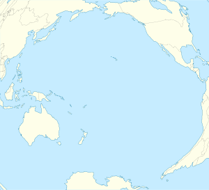
Location of Easter Island in the Pacific Ocean
تصاویر
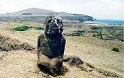
- Moais


بیرونی روابط
حوالہ جات
- Pending the enactment of a special charter, the island will continue to be governed as a province of the Valparaíso Region.
- {{cite web|url=http://www.censo.cl/2012/08/resultados_preliminares_censo_2012.pdf%7Ctitle=Resultados Preliminares Censo de Población y Vivienda 2012|publisher=Instituto Nacional de Estadísticas|date=31 August 2012|language=Spanish
| ویکی کومنز پر جزیرہ ایسٹر سے متعلق سمعی و بصری مواد ملاحظہ کریں۔ |
اوقیانوسیہ کے ممالک اور خطے | |||||||||||||||||||
|---|---|---|---|---|---|---|---|---|---|---|---|---|---|---|---|---|---|---|---|
| خود مختار ریاستیں | .svg.png) | ||||||||||||||||||
| انحصاریاں اور دیگر خطے |
| ||||||||||||||||||
1 اکثر جنوب مشرقی ایشیا میں شامل | |||||||||||||||||||
This article is issued from
Wikipedia.
The text is licensed under Creative
Commons - Attribution - Sharealike.
Additional terms may apply for the media files.