خلیج جروس علاقہ
خلیج جروس علاقہ (Jervis Bay Territory) دولت مشترکہ آسٹریلیا کا ایک علاقہ ہے جو خلیج جروس کے کنارے واقع ہے۔ یہ ریاست نیو ساؤتھ ویلز سے الگ ہو کر 1915ء میں دولت مشترکہ حکومت میں شامل کیا گیا [5][6] تا کہ کینبرا وفاقی دارالحکومت کو سمندر تک رسائی ہو۔
| خلیج جروس علاقہ | |||||||||
|---|---|---|---|---|---|---|---|---|---|
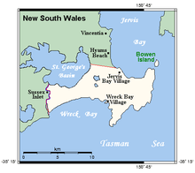 | |||||||||
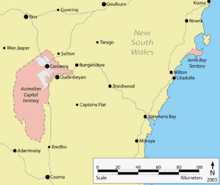 خلیج جروس میں مقام | |||||||||
 خلیج جروس علاقہ | |||||||||
| متناسقات | 35°7′11″S 150°43′57″E | ||||||||
| آبادی | 377 (آسٹریلیا 2011 میں مردم شماری)[1] | ||||||||
| • کثافت | 5.6/کلو میٹر2 (/مربع میل) | ||||||||
| بنیاد | 1915 | ||||||||
| ڈاک رمز | 2540 | ||||||||
| علاقہ | 67.8 کلو میٹر2 (26.2 مربع میل)[2] | ||||||||
| منطقہ وقت | آسٹریلیا میں وقت (یو ٹی سی+10) | ||||||||
| • گرمیوں میں (ڈی ایس ٹی) | آسٹریلیا میں وقت (یو ٹی سی+11) | ||||||||
| مقام | |||||||||
| وفاقی ڈویژن | Fraser[3] | ||||||||
| |||||||||
حوالہ جات
- Australian Bureau of Statistics (31 اکتوبر 2012)۔ "Jervis Bay (OT)"۔ 2011 Census QuickStats۔ اخذ شدہ بتاریخ 8 مئی 2013۔
- Australian Bureau of Statistics (31 اکتوبر 2012)۔ "2011 Community Profiles: Jervis Bay (OT)"۔ 2011 Census of Population and Housing۔ اخذ شدہ بتاریخ 8 مئی 2013۔
- "Fraser"۔ Australian Electoral Commission۔ 21 نومبر 2012۔ اخذ شدہ بتاریخ 8 مئی 2013۔
- "Jervis Bay (Point Perpendicular AWS)"۔ Climate statistics for Australian locations۔ Bureau of Meteorology۔ اخذ شدہ بتاریخ 8 مئی 2013۔
- Jervis Bay Territory Acceptance Act 1915 (Cth)
- "Seat of Government Surrender Act (NSW) Act 9 of 1915". This document, assented to by the Governor-General in 1915, provided for the transfer of 28 square miles of land at Jervis Bay to the Commonwealth, in addition to the areas surrendered under the Seat of Government Acceptance Act 1909 and the Seat of Government Surrender Act 1909. Museum of Australian Democracy. Retrieved 17 January 2013.
مزید دیکھیے
| ریاستیں اور علاقہ جات | ||
|---|---|---|
| بیرونی علاقہ جات | ||
| سابقہ علاقہ جات |
| |
This article is issued from
Wikipedia.
The text is licensed under Creative
Commons - Attribution - Sharealike.
Additional terms may apply for the media files.