

Using the Data Table
 ShareCompartir
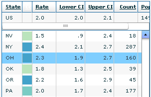
The data table allows you to view the data you selected for each state and the District of Columbia in an interactive table. Each state is represented by a row in the table. When you highlight a row in the table, InCA displays the data for the state represented by the highlighted row in the interactive map and the bubble plot simultaneously.
The following columns are displayed in the table—
- State: The state name.
- Color (no label): A color code indicating the state’s classification.
- Rate: The incidence or death rate for the site you selected.
- Lower CI: The lower confidence interval for the rate.
- Upper CI: The upper confidence interval for the rate.
- Count: The incidence or death count for the site you selected.
- Population: The population count from which the rate was derived.
With the exception of the Lower CI and Upper CI columns, all columns are sortable. Click on a column heading to sort data by the specific column. Click once to sort in ascending order, and click again to sort in descending order. The row at the top of the table displays data for the U.S. population as a whole. This row does not scroll and can be viewed at all times.
- Page last reviewed: July 27, 2009
- Page last updated: November 3, 2015
- Content source: