মার্মারা সাগর
মার্মারা সাগর /ˈmɑːrmərə/ (তুর্কী: Marmara Denizi, গ্রিক: Θάλασσα του Μαρμαρά), আরোও পরিচিত ধ্রুপদি সভ্যতার কাল থেকে প্রপন্টিস (Propontis) (গ্রিক: Προποντίς), সম্পূর্ণভাবে তুরস্ক সীমানার ভিতর একটি অন্তর্দেশীয় সাগর, যা কৃষ্ণ সাগরের সাথে এজিয়ান সাগরের সংযোগ স্থাপন করে।
| মার্মারা সাগর | |
|---|---|
| স্থানাঙ্ক | ৪০°৪১′১২″ উত্তর ২৮°১৯′৭″ পূর্ব |
| অববাহিকার দেশসমূহ | তুরস্ক |
| পৃষ্ঠতল অঞ্চল | ১১,৩৫০ কিমি২ (৪,৩৮০ মা২) |
| গড় গভীরতা | ৪৯৪ মি (১,৬২১ ফু) |
| সর্বাধিক গভীরতা | ১,৩৭০ মি (৪,৪৯০ ফু) |
| পানির আয়তন | ৩,৩৭৮ কিমি৩ (৮১০ মা৩) |
| দ্বীপপুঞ্জ | Adalar, etc. |
| জনবসতি | ইস্তানবুল, Bursa, Çanakkale, Kocaeli, Tekirdağ, Sakarya and their towns. |
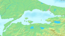
মার্মারা সাগরের মানচিত্র।
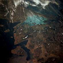
মহাশূন্য থেকে মার্মারা সাগরের আলোকচিত্র (এসটিএস ৪০, ১৯৯১)। সমুদ্র হালকা রঙে।

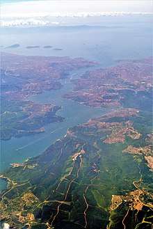
This astronaut photograph highlights the metropolitan area of Izmit along the northern and eastern shores of the Sea of Marmara, at the end of the Gulf of Izmit.
আরোও দেখুন
গ্যালারি
 View of Marmara Sea from Istanbul (Kumkapı)
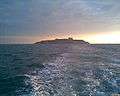 Sea of Marmara approaching Yassıada
.jpg) View of the Marmara Sea from Yeşilköy
View of the Marmara Sea from Yeşilköy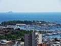 View of the Marmara Sea from Kadıköy
![]()
তথ্যসূত্র
বহিঃসংযোগ
This article is issued from
Wikipedia.
The text is licensed under Creative
Commons - Attribution - Sharealike.
Additional terms may apply for the media files.