لوزیانا کے پیرشوں کی فہرست
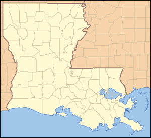
یہ فہرست لوزیانا کے پیرش (List of parishes in Louisiana) ہے۔
| فہرست لوزیانا کے پیرش | |
|---|---|
| زمرہ | زمرہ:درجہ دوم انتظامی ملکی ذیلی تقسیم انتظامی تقسیم |
| مقام | لوویزیانا |
| تعداد | 64 پیرش |
| آبادی | 5,066 (ٹینساس) – 440,171 (ایسٹ بیٹون روج پیرش) |
| رقبہ | 203 مربع میل (530 کلومیٹر2) (ویسٹ بیٹون روج پیرش) – 2,429 مربع میل (6,290 کلومیٹر2) (پلیکماینز پیرش) |
| حکومت | مقامی حکومت |
| ذیلی تقسیمات | شہر، ٹاؤن، مردم شماری نامزد مقام, انانکارپوریٹڈ علاقہ |
فہرست
| Parish |
ایف آئی پی ایس رموز [1] |
Parish seat [2] |
Established [2] |
Origin |
Etymology [3] |
آبادی [2] |
رقبہ [2] |
نقشہ |
|---|---|---|---|---|---|---|---|---|
| Acadia Parish | 001 | Crowley | 1886 | from part of St. Landry Parish. | Named for the Acadians who settled the area. | 61,773 | 658 sq mi (1,704 km2) | 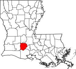 |
| Allen Parish | 003 | Oberlin | 1912 | from part of Calcasieu Parish. | Henry Watkins Allen, the Confederate governor of لوویزیانا | 25,764 | 766 sq mi (1,984 km2) | 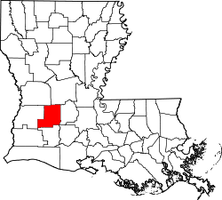 |
| Ascension Parish | 005 | Donaldsonville | 1807 | One of the original 19 parishes. | Named for the Ascension of Our Lord Catholic Church in Donaldsonville, Louisiana, which was named after the صعود مسیح | 107,215 | 303 sq mi (785 km2) | 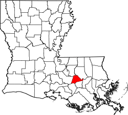 |
| Assumption Parish | 007 | Napoleonville | 1807 | One of the original 19 parishes. | Named for the Assumption Roman Catholic Church, the oldest in the state, which was named after the عروج مریم | 23,421 | 364 sq mi (943 km2) | 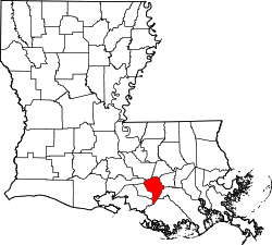 |
| Avoyelles Parish | 009 | Marksville | 1807 | One of the original 19 parishes. | The Avoyel Native American people | 42,073 | 866 sq mi (2,243 km2) | 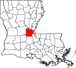 |
| Beauregard Parish | 011 | DeRidder | 1912 | from part of Calcasieu Parish. | Confederate general P. G. T. Beauregard | 35,654 | 1,166 sq mi (3,020 km2) | 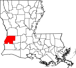 |
| Bienville Parish | 013 | Arcadia | 1848 | from part of Claiborne Parish. | Named after the founder of the city of نیو اورلینز, Jean-Baptiste Le Moyne de Bienville | 14,353 | 822 sq mi (2,129 km2) | 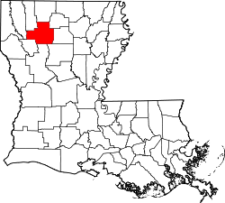 |
| Bossier Parish | 015 | Benton | 1843 | from part Claiborne Parish. | ریاستہائے متحدہ ایوان نمائندگان Pierre Bossier | 116,979 | 867 sq mi (2,246 km2) | 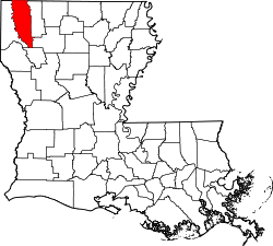 |
| Caddo Parish | 017 | Shreveport | 1838 | from part of Natchitoches Parish. | Named for the Caddo Native American people | 254,969 | 937 sq mi (2,427 km2) | 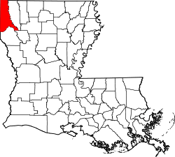 |
| Calcasieu Parish | 019 | Lake Charles | 1840 | from part of St. Landry Parish. | Calcasieu, meaning crying eagle, is said to be the name of an Atakapa Native American leader | 192,768 | 1,094 sq mi (2,833 km2) | 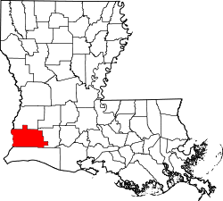 |
| Caldwell Parish | 021 | Columbia | 1838 | from part of Catahoula Parish and Ouachita Parish. | Named for the Caldwell family, which owned a large plantation and remains politically active in the state. | 10,132 | 541 sq mi (1,401 km2) | 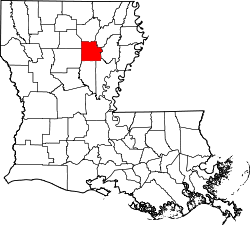 |
| Cameron Parish | 023 | Cameron | 1870 | from parts of Calcasieu Parish and Vermilion Parish. | U.S. Secretary of War Simon Cameron | 6,839 | 1,932 sq mi (5,004 km2) | 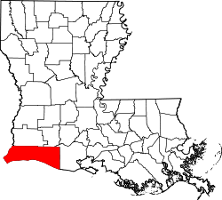 |
| Catahoula Parish | 025 | Harrisonburg | 1808 | from parts of Ouachita Parish and Rapides Parish. | Catahoula Lake, formerly within the parish's boundaries and named from a Taensa word meaning big, clear lake | 10,407 | 739 sq mi (1,914 km2) | 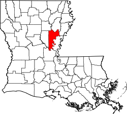 |
| Claiborne Parish | 027 | Homer | 1828 | from part of Natchitoches Parish. | Governor of Louisiana William C. C. Claiborne | 17,195 | 768 sq mi (1,989 km2) |  |
| Concordia Parish | 029 | Vidalia | 1807 | One of the original 19 parishes. | Name is of uncertain origin; may be from an early land grant called New Concordia, from the "concord" reached by local authorities over a mutual surrender of slaves or for a mansion called Concord which was owned by Spanish Governor Manuel Gayoso de Lemos | 20,822 | 749 sq mi (1,940 km2) |  |
| De Soto Parish | 031 | Mansfield | 1843 | from parts of Caddo Parish and Natchitoches Parish. | Spanish explorer Hernando de Soto | 26,656 | 895 sq mi (2,318 km2) | 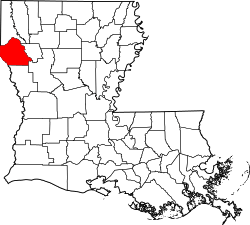 |
| East Baton Rouge Parish | 033 | Baton Rouge | 1810 | from West Florida territory. | French phrase bâton rouge meaning red stick. A red stick was used by local Native Americans to mark the boundaries between tribal territories | 440,171 | 471 sq mi (1,220 km2) |  |
| East Carroll Parish | 035 | Lake Providence | 1877 | when Carroll Parish was divided. | Charles Carroll of Carrollton, the last surviving signer of the U.S. Declaration of Independence | 7,759 | 442 sq mi (1,145 km2) |  |
| East Feliciana Parish | 037 | Clinton | 1824 | when Feliciana Parish was divided. | Felicite de Gálvez, the wife of Bernardo de Gálvez, a Spanish governor of لوزیانا (نیا ہسپانیہ) | 20,267 | 456 sq mi (1,181 km2) |  |
| Evangeline Parish | 039 | Ville Platte | 1910 | from part of St. Landry Parish. | Acadian heroine of the poem "Evangeline" by Henry Wadsworth Longfellow | 33,984 | 680 sq mi (1,761 km2) | 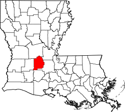 |
| Franklin Parish | 041 | Winnsboro | 1843 | from parts of Carroll Parish, Catahoula Parish, Madison Parish and Ouachita Parish | Founding Father بن یمین فرینکلن | 20,767 | 636 sq mi (1,647 km2) | 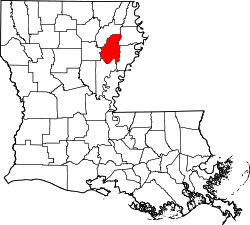 |
| Grant Parish | 043 | Colfax | 1869 | from parts of Rapides Parish and Winn Parish. | U.S. President اولیسس ایس گرانٹ | 22,309 | 664 sq mi (1,720 km2) | 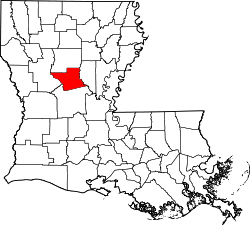 |
| Iberia Parish | 045 | New Iberia | 1868 | from parts of St. Martin Parish and St. Mary Parish. | Named by Spanish settlers in honor of the جزیرہ نما آئبیریا | 73,240 | 1,031 sq mi (2,670 km2) | 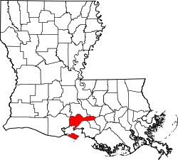 |
| Iberville Parish | 047 | Plaquemine | 1807 | One of the original 19 parishes. | Explorer Pierre Le Moyne d'Iberville, the brother of Jean-Baptiste Le Moyne de Bienville | 33,387 | 653 sq mi (1,691 km2) | 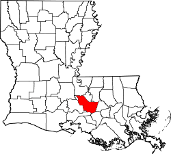 |
| Jackson Parish | 049 | Jonesboro | 1845 | from parts of Claiborne Parish, Ouachita Parish and Union Parish | U.S. President اینڈریو جیکسن | 16,274 | 580 sq mi (1,502 km2) | 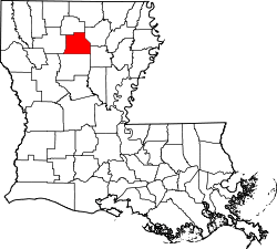 |
| Jefferson Parish | 051 | Gretna | 1825 | from part of Orleans Parish | Founding Father ٹامس جیفرسن | 432,552 | 642 sq mi (1,663 km2) | 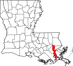 |
| Jefferson Davis Parish | 053 | Jennings | 1912 | from part of Calcasieu Parish. | Jefferson Davis, president of the Confederate States of America | 31,594 | 659 sq mi (1,707 km2) |  |
| Lafayette Parish | 055 | Lafayette | 1823 | from part of St. Martin Parish. | French-born امریکی جنگ انقلاب hero, the Marquis de Lafayette | 221,578 | 270 sq mi (699 km2) | 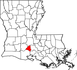 |
| Lafourche Parish | 057 | Thibodaux | 1807 | One of the original 19 parishes. Was named Interior Parish until 1812 and Lafourche Interior Parish until 1853. | French phrase la fourche or in English, the fork; Bayou Lafourche, or Fork Bayou, is a fork of the دریائے مسیسپی | 96,318 | 1,472 sq mi (3,812 km2) | 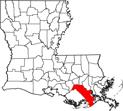 |
| La Salle Parish | 059 | Jena | 1908 | from part of Catahoula Parish. | Explorer René-Robert Cavelier, Sieur de La Salle | 14,890 | 663 sq mi (1,717 km2) |  |
| Lincoln Parish | 061 | Ruston | 1873 | from parts of Bienville Parish, Claiborne Parish, Jackson Parish and Union Parish. | صدر ریاستہائے متحدہ امریکہ ابراہام لنکن | 46,735 | 472 sq mi (1,222 km2) | 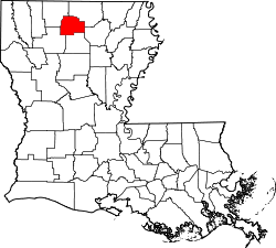 |
| Livingston Parish | 063 | Livingston | 1832 | from part of St. Helena Parish. | وزیر خارجہ ریاستہائے متحدہ امریکہ Edward Livingston, brother of Robert R. Livingston who negotiated the لوزیانا کی خرید و فروخت | 128,026 | 703 sq mi (1,821 km2) | 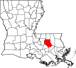 |
| Madison Parish | 065 | Tallulah | 1838 | from Concordia Parish. | U.S. President جیمز میڈیسن | 12,093 | 651 sq mi (1,686 km2) | 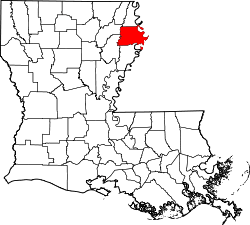 |
| Morehouse Parish | 067 | Bastrop | 1844 | from parts of Carroll Parish and Ouachita Parish. | Abraham Morehouse, who led the first settlers into the region | 27,979 | 805 sq mi (2,085 km2) |  |
| Natchitoches Parish | 069 | Natchitoches | 1807 | One of the original 19 parishes. | The Natchitoches Native American people | 39,566 | 1,299 sq mi (3,364 km2) | 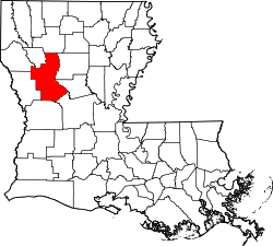 |
| Orleans Parish | 071 | New Orleans | 1807 | One of the original 19 parishes. Today coterminous with the City of New Orleans. | Named after the Duke of Orléans, the regent of France | 343,829 | 350 sq mi (906 km2) | 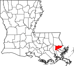 |
| Ouachita Parish | 073 | Monroe | 1807 | One of the original 19 parishes. | The ویچیتا قوم Native American people | 153,720 | 633 sq mi (1,639 km2) | 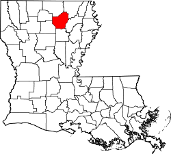 |
| Plaquemines Parish | 075 | Pointe a la Hache | 1807 | One of the original 19 parishes. | A word meaning persimmons created from the Louisiana Creole French and the Atakapa language | 23,042 | 2,429 sq mi (6,291 km2) | 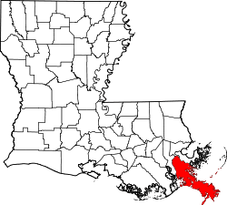 |
| Pointe Coupee Parish | 077 | New Roads | 1807 | One of the original 19 parishes. | French phrase la pointe coupée or in English, the cut-off point, which refers to a bend in the دریائے مسیسپی | 22,802 | 591 sq mi (1,531 km2) |  |
| Rapides Parish | 079 | Alexandria | 1807 | One of the original 19 parishes. | Named for local river rapids (French: rapides) | 131,613 | 1,362 sq mi (3,528 km2) | 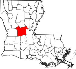 |
| Red River Parish | 081 | Coushatta | 1871 | from parts of Bienville Parish, Bossier Parish, Caddo Parish and Natchitoches Parish. | Named for the Red River, which is part of the دریائے مسیسپی نکاسی طاس | 9,091 | 402 sq mi (1,041 km2) |  |
| Richland Parish | 083 | Rayville | 1868 | from parts of Carroll Parish, Franklin Parish, Morehouse Parish and Ouachita Parish. | Named for its rich land | 20,725 | 564 sq mi (1,461 km2) | 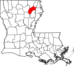 |
| Sabine Parish | 085 | Many | 1843 | from parts of Caddo Parish and Natchitoches Parish. | Named for the Sabine River and the so-called Sabine Free State | 24,233 | 1,012 sq mi (2,621 km2) | 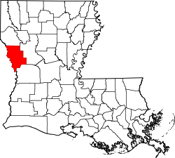 |
| Saint Bernard Parish | 087 | Chalmette | 1807 | One of the original 19 parishes. | Saint Bernard, سرپرست بزرگ of Bernardo de Galvez, the Spanish governor who granted land to the Canary Islanders settling the area in 1778 | 35,897 | 1,794 sq mi (4,646 km2) |  |
| Saint Charles Parish | 089 | Hahnville | 1807 | One of the original 19 parishes. | Saint Charles | 52,780 | 410 sq mi (1,062 km2) |  |
| Saint Helena Parish | 091 | Greensburg | 1810 | from West Florida territory. | Saint Helena | 11,203 | 409 sq mi (1,059 km2) |  |
| Saint James Parish | 093 | Convent | 1807 | One of the original 19 parishes. | یعقوب بن زبدی | 22,102 | 258 sq mi (668 km2) |  |
| Saint John the Baptist Parish | 095 | Edgard | 1807 | One of the original 19 parishes. | یحییٰ علیہ السلام | 45,924 | 348 sq mi (901 km2) |  |
| Saint Landry Parish | 097 | Opelousas | 1807 | One of the original 19 parishes. | Saint Landry | 83,384 | 939 sq mi (2,432 km2) |  |
| Saint Martin Parish | 099 | Saint Martinville | 1807 | One of the original 19 parishes. | Saint Martin | 52,160 | 817 sq mi (2,116 km2) |  |
| Saint Mary Parish | 101 | Franklin | 1811 | from part of St. Martin Parish. | مریم علیہا السلام. | 54,650 | 612 sq mi (1,585 km2) |  |
| Saint Tammany Parish | 103 | Covington | 1810 | from West Florida territory. | Legendary Indian Chief Tamanend. | 233,740 | 1,124 sq mi (2,911 km2) |  |
| Tangipahoa Parish | 105 | Amite | 1869 | from parts of Livingston Parish, St. Helena Parish, St. Tammany Parish and Washington Parish. | Comes from an Acolapissa word meaning ear of corn or those who gather corn | 121,097 | 823 sq mi (2,132 km2) | 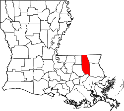 |
| Tensas Parish | 107 | Saint Joseph | 1843 | from part of Concordia Parish. | The Taensa Native American people. | 5,066 | 641 sq mi (1,660 km2) | 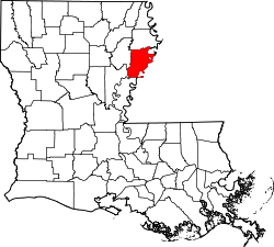 |
| Terrebonne Parish | 109 | Houma | 1822 | from part of Lafourche Interior Parish. | French phrase terre bonne or in English, good earth | 111,860 | 2,080 sq mi (5,387 km2) | 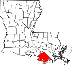 |
| Union Parish | 111 | Farmerville | 1839 | from part of Ouachita Parish. | Named for the union of states which make up the U.S. | 22,721 | 905 sq mi (2,344 km2) | 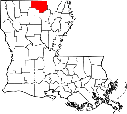 |
| Vermilion Parish | 113 | Abbeville | 1844 | from part of Lafayette Parish. | Both the Vermilion River and Vermilion Bay | 57,999 | 1,538 sq mi (3,983 km2) | 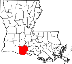 |
| Vernon Parish | 115 | Leesville | 1871 | from parts of Natchitoches Parish, Rapides Parish and Sabine Parish. | Mount Vernon, the home of جارج واشنگٹن, the first U.S. President | 52,334 | 1,341 sq mi (3,473 km2) | 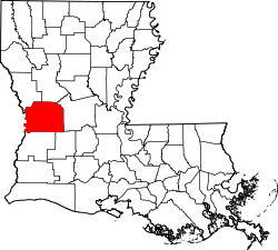 |
| Washington Parish | 117 | Franklinton | 1819 | from part of St. Tammany Parish. | U.S. President جارج واشنگٹن | 47,168 | 676 sq mi (1,751 km2) | 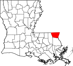 |
| Webster Parish | 119 | Minden | 1871 | from parts of Bienville Parish, Bossier Parish and Claiborne Parish. | U.S. statesman Daniel Webster | 41,207 | 615 sq mi (1,593 km2) | 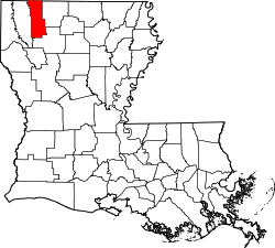 |
| West Baton Rouge Parish | 121 | Port Allen | 1807 | One of the original 19 parishes. Was named Baton Rouge Parish until 1812. | French phrase bâton rouge meaning red stick. A red stick was used by local Native Americans to mark the boundaries between tribal territories | 23,788 | 203 sq mi (526 km2) |  |
| West Carroll Parish | 123 | Oak Grove, West Carroll Parish | 1877 | when Carroll Parish was divided. | Charles Carroll of Carrollton, the last surviving signer of the U.S. Declaration of Independence | 11,604 | 360 sq mi (932 km2) |  |
| West Feliciana Parish | 125 | Saint Francisville | 1824 | when Feliciana Parish was divided. | Felicite de Gálvez, the wife of Bernardo de Gálvez, a Spanish governor of لوزیانا (نیا ہسپانیہ) | 15,625 | 1,051 sq mi (2,722 km2) |  |
| Winn Parish | 127 | Winnfield | 1852 | from parts of Catahoula Parish, Natchitoches Parish and Rapides Parish. | Louisiana state legislator Walter Winn | 15,313 | 957 sq mi (2,479 km2) | 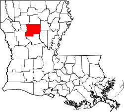 |
بیرونی روابط
حوالہ جات
- "EPA County FIPS Code Listing"۔ EPA.gov۔ مورخہ 26 دسمبر 2018 کو اصل سے آرکائیو شدہ۔ اخذ شدہ بتاریخ 2008-02-23۔
- National Association of Counties۔ "NACo - Find a county"۔ مورخہ 2008-06-04 کو اصل سے آرکائیو شدہ۔ اخذ شدہ بتاریخ 2008-06-12۔
- Louisiana Dept. of Public Health Parish Profiles
This article is issued from
Wikipedia.
The text is licensed under Creative
Commons - Attribution - Sharealike.
Additional terms may apply for the media files.