اقوام متحدہ جغرافیائی خاکہ
اقوام متحدہ جغرافیائی خاکہ (United Nations geoscheme) ایک ایسا نظام ہے جو دنیا کے ممالک کو علاقائی اور ذیلی علاقائی گروہوں میں تقسیم کرتا ہے۔[1][2][3]
اقوام متحدہ کے شماریاتی علاقہ جات
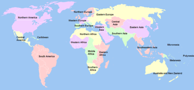
علاقوں اور ذیلی علاقوں کی فہرست
- افریقا – مزید دیکھیے : اقوام متحدہ جغرافیائی خاکہ برائے افریقا
- * مشرقی افریقا
- * وسطی افریقا
- * شمالی افریقا
- * جنوبی افریقا (خطہ)
- * مغربی افریقا
- بر اعظم امریکا – مزید دیکھیے : اقوام متحدہ جغرافیائی خاکہ برائے امریکین
- * لاطینی امریکا اور کیریبین
- * جنوبی امریکا
- * کیریبین *
- * وسطی امریکا *
- * شمالی امریکا (خطہ) *[3]
- ایشیا ** – مزید دیکھیے : اقوام متحدہ جغرافیائی خاکہ برائے ایشیا
- * وسط ایشیا
- * مشرقی ایشیا
- * جنوبی ایشیا
- * جنوب مشرقی ایشیا
- * مغربی ایشیا
- یورپ ** – مزید دیکھیے : اقوام متحدہ جغرافیائی خاکہ برائے یورپ
- * مشرقی یورپ - اقوام متحدہ شمالی ایشیا (روس کے ایشیائی علاقہ) اس ذیلی علاقہ میں شامل کرتا ہے
- * شمالی یورپ
- * جنوبی یورپ
- * مغربی یورپ
- اوقیانوسیہ – مزید دیکھیے : اقوام متحدہ جغرافیائی خاکہ برائے اوقیانوسیہ
- * آسٹریلیا اور نیوزی لینڈ
- * میلانیشیا
- * مائیکرونیشیا
- * پولینیشیا
مزید دیکھیے
حوالہ جات
- Ajey Lele (20 اکتوبر 2012)۔ Asian Space Race: Rhetoric or Reality?۔ Springer Science & Business Media۔ صفحات 8–۔ آئی ایس بی این 978-81-322-0733-7۔ مورخہ 24 دسمبر 2018 کو اصل سے آرکائیو شدہ۔
Te best option to identify the states from Asia could be use the United Nations (UN) geoscheme for Asia. As per this, Asia is subdivided to four broad categories: Wastern Asia, .. ...
- Reuben P. Keller؛ Marc W. Cadotte؛ Glenn Sandiford (24 نومبر 2014)۔ Invasive Species in a Globalized World: Ecological, Social, and Legal Perspectives on Policy۔ University of Chicago Press۔ صفحات 128–۔ آئی ایس بی این 978-0-226-16618-6۔ مورخہ 24 دسمبر 2018 کو اصل سے آرکائیو شدہ۔
- United Nations Statistics Division - Standard Country and Area Codes Classifications
This article is issued from
Wikipedia.
The text is licensed under Creative
Commons - Attribution - Sharealike.
Additional terms may apply for the media files.