பொனெய்ர்
பொனெய்ர் (ஒலிப்பு: /bɒˈnɛər/; டச்சு: Bonaire, பப்பியாமெந்தோ: Boneiru) நெதர்லாந்து இராச்சியத்திற்குட்பட்ட ஒரு விசேட மாநகரசபை ஆகும்.[3]. இது பொனெய்ர் எனும் தீவையும் க்லீன் பொனெய்ர் எனும் மக்களற்ற தீவையும் கொண்டது. இது சிறிய அண்டிலிசுவில் உள்ள காற்றெதிர் அண்டிலிசுவின் ஏ.பி.சி. தீவுகளின் ஒரு பகுதியாகும். அரூபாவும் குராசோவும் ஏ.பி.சி. தீவுகளின் ஏனைய பகுதிகளாகும். பொனெய்ர் என்ற பெயர் "நல்ல காற்று" என பொருள்படும்.
| பொனெய்ர் Boneiru
|
||||||
|---|---|---|---|---|---|---|
|
||||||
| நாட்டுப்பண்: "Tera di Solo y suave biento" | ||||||
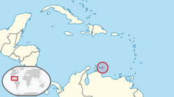 Location of பொனெய்ர் |
||||||
| தலைநகரம் மற்றும் பெரிய நகரம் | Kralendijk 12°15′N 68°28′W | |||||
| ஆட்சி மொழி(கள்) | டச்சு, பப்பியாமெந்தோ[1] | |||||
| அரசாங்கம் | See Politics of the Netherlands | |||||
| • | Lt. Governor | Glenn Thodé | ||||
| முடியாட்சி நெதர்லாந்து இராச்சியத்திற்கு உட்பட்டது | ||||||
| பரப்பு | ||||||
| • | மொத்தம் | 294 கிமீ2 113 சதுர மைல் |
||||
| மக்கள் தொகை | ||||||
| • | 2010 கணக்கெடுப்பு | 15,800 | ||||
| • | அடர்த்தி | 49/km2 (ranked as part of N. A.) 99/sq mi |
||||
| நாணயம் | அமெரிக்க டொலர் (USD) | |||||
| நேர வலயம் | -4 (ஒ.அ.நே-4) | |||||
| வாகனம் செலுத்தல் | right | |||||
| அழைப்புக்குறி | 599 | |||||
| இணையக் குறி | .an,[2] .nl | |||||
| 1. | Caribbean portal | |||||

.svg.png)
மேற்கோள்கள்
- Papiamentu can be used in relations with the government
"Invoeringswet openbare lichamen Bonaire, Sint Eustatius en Saba" (Dutch). wetten.nl. பார்த்த நாள் 2011-01-01. - The domain for the Netherlands Antilles has remained active after its dissolution. The ISO 3166-1 alpha-2 code BQ was established for the entity "Bonaire, Saint Eustatius, Saba". ("ISO 3166-1 decoding table". International Organization for Standardization. பார்த்த நாள் 2010-12-17.) An Internet ccTLD has however not been established by the IANA, and it is unknown if it will be opened for registration.
- (டச்சு) "Wet openbare lichamen Bonaire, Sint Eustatius en Saba
(Law on the public bodies of Bonaire, Saint Eustatius and Saba)". Dutch Government. பார்த்த நாள் 14 October 2010.
This article is issued from
Wikipedia.
The text is licensed under Creative
Commons - Attribution - Sharealike.
Additional terms may apply for the media files.