الاباما کی کاؤنٹیوں کی فہرست
الاباما کاؤنٹیاں (کلک نقشہ)
امریکی ریاست الاباما کی 67 کاؤنٹیاں ہیں۔[1]
کاؤنٹیاں
| کاؤنٹی |
ایف آئی پی ایس رموز [2] |
کاؤنٹی نشست [3] |
لائسنس # [4] |
تشکیل [3] |
سے قائم [5] |
اشتقاقیات [6][7] | کثافت |
آبادی [8] |
رقبہ [9] |
نقشہ |
|---|---|---|---|---|---|---|---|---|---|---|
| Autauga County | 001 | Prattville | 4 | 1818 | Montgomery County | The Autauga or Atagi people, Native Americans who were a sub-group of the Alibamu | 93.46 | 55,514 | 594 sq mi (1,538 km2) | 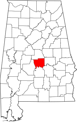 |
| Baldwin County | 003 | Bay Minette | 5 | 1809 | Washington County and West Florida | Abraham Baldwin (1754–1807), U.S. legislator from Georgia | 119.99 | 190,790 | 1,590 sq mi (4,118 km2) | 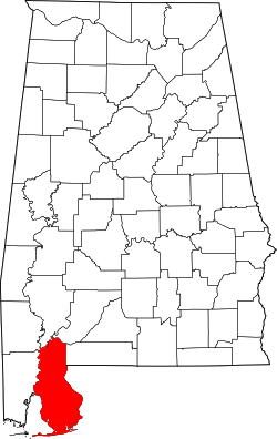 |
| Barbour County | 005 | Clayton | 6 | 1832 | Pike County | James Barbour (1775–1842), Governor of Virginia and ریاستہائے متحدہ سینٹ | 30.74 | 27,201 | 885 sq mi (2,292 km2) | 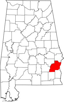 |
| Bibb County | 007 | Centreville | 7 | 1818 | Montgomery County (as Cahawba County) | William Wyatt Bibb (1781–1820), 1st Governor of Alabama | 36.27 | 22,597 | 623 sq mi (1,614 km2) | 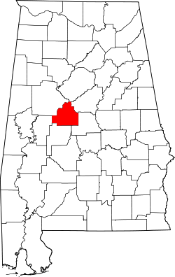 |
| Blount County | 009 | Oneonta | 8 | 1818 | Montgomery County and Indian territories | Willie Blount (1768–1835), Governor of Tennessee. | 89.65 | 57,826 | 645 sq mi (1,671 km2) | 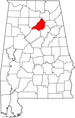 |
| Bullock County | 011 | Union Springs | 9 | 1866 | Barbour, Macon, Montgomery, and Pike counties | Edward Bullock (1822–1861), colonel in the Confederate States Army | 16.81 | 10,474 | 623 sq mi (1,614 km2) | 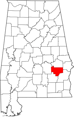 |
| Butler County | 013 | Greenville | 10 | 1819 | Conecuh and Monroe counties | William Butler (?–1818), captain in Creek War | 26.14 | 20,307 | 777 sq mi (2,012 km2) | 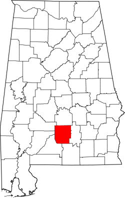 |
| Calhoun County | 015 | Anniston | 11 | 1832 | St. Clair County (as Benton County) | John C. Calhoun (1782–1850), 7th ریاستہائے متحدہ کے نائب صدور کی فہرست | 193.56 | 117,296 | 606 sq mi (1,570 km2) | 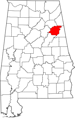 |
| Chambers County | 017 | LaFayette | 12 | 1832 | Montgomery County | Henry H. Chambers (1790–1826), ریاستہائے متحدہ سینٹ | 57.06 | 34,064 | 597 sq mi (1,546 km2) | 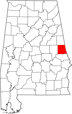 |
| Cherokee County | 019 | Centre | 13 | 1836 | چروکی territory | چروکی people, whose lands included Alabama | 46.97 | 26,021 | 554 sq mi (1,435 km2) | 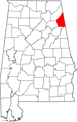 |
| Chilton County | 021 | Clanton | 14 | 1868 | Autauga, Bibb, Perry, and Shelby counties (as Baker County) | William Parish Chilton (1810–1871), Alabama Supreme Court Justice and Confederate congressman | 63.23 | 43,819 | 693 sq mi (1,795 km2) | 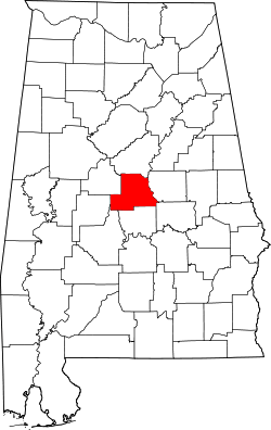 |
| Choctaw County | 023 | Butler | 15 | 1847 | Sumter and Washington counties | Choctaw people, whose lands included Alabama | 14.92 | 13,633 | 914 sq mi (2,367 km2) | 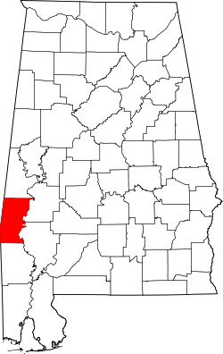 |
| Clarke County | 025 | Grove Hill | 16 | 1812 | Washington County | John Clarke (1766–1832), منصبِ جامع from Georgia | 20.32 | 25,161 | 1,238 sq mi (3,206 km2) | 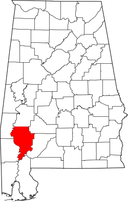 |
| Clay County | 027 | Ashland | 17 | 1866 | Randolph and Talladega counties | ہینری کلے (1777–1852), U.S. legislator from کینٹکی | 22.24 | 13,435 | 604 sq mi (1,564 km2) | 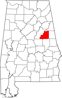 |
| Cleburne County | 029 | Heflin | 18 | 1866 | Calhoun, Randolph , and Talladega counties | Patrick Cleburne (1828–1864), میجر جنرل in Confederate States Army | 26.49 | 14,832 | 560 sq mi (1,450 km2) | 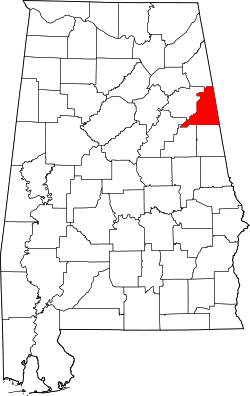 |
| Coffee County | 031 | Elba and Enterprise[10] | 19 | 1841 | Dale County | John Coffee (1772–1833), military leader in War of 1812 and Creek War | 75.48 | 51,252 | 679 sq mi (1,759 km2) | 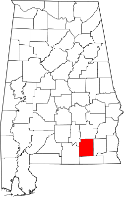 |
| Colbert County | 033 | Tuscumbia | 20 | 1867 | Franklin County | George Colbert (1764–1839) and Levi Colbert (1759–1834), Chickasaw chiefs | 91.81 | 54,446 | 593 sq mi (1,536 km2) | 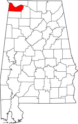 |
| Conecuh County | 035 | Evergreen | 21 | 1818 | Monroe County | The Conecuh River, which flows through the county | 15.27 | 12,981 | 850 sq mi (2,201 km2) | 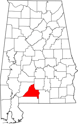 |
| Coosa County | 037 | Rockford | 22 | 1832 | Montgomery County | The Coosa River, which flows through the county, and is itself named after a Native American village | 16.84 | 10,966 | 651 sq mi (1,686 km2) | 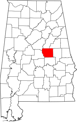 |
| Covington County | 039 | Andalusia | 23 | 1821 | Henry County | Leonard Covington (1768–1813), Brigadier General in War of 1812 and ریاستہائے متحدہ ایوان نمائندگان | 36.85 | 37,955 | 1,030 sq mi (2,668 km2) | 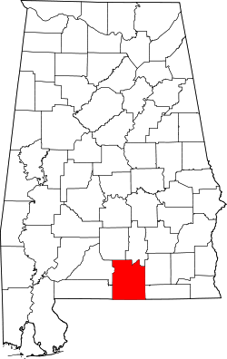 |
| Crenshaw County | 041 | Luverne | 24 | 1866 | Butler, Coffee, Covington, Lowndes, and Pike Counties | Anderson Crenshaw (1783–1847), Alabama Supreme Court justice and early settler | 23.12 | 14,083 | 609 sq mi (1,577 km2) | 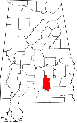 |
| Cullman County | 043 | Cullman | 25 | 1877 | Blount, Morgan, and Winston counties | Colonel John G. Cullmann (1823–1895), founder of county seat | 109.44 | 80,440 | 735 sq mi (1,904 km2) | 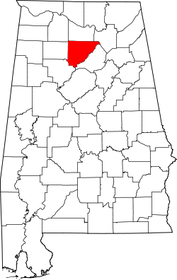 |
| Dale County | 045 | Ozark | 26 | 1824 | Covington and Henry counties | Samuel Dale (1772–1841), Brigadier General and state legislator | 89.92 | 50,444 | 561 sq mi (1,453 km2) | 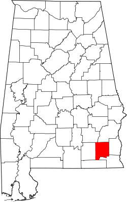 |
| Dallas County | 047 | Selma | 27 | 1818 | Monroe and Montgomery counties | Alexander James Dallas (1759–1817) , U.S. Secretary of Treasury | 44.76 | 43,820 | 979 sq mi (2,536 km2) | 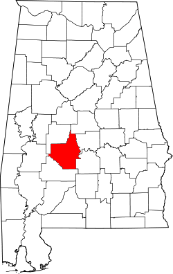 |
| DeKalb County | 049 | Fort Payne | 28 | 1836 | چروکی territory | Johann de Kalb (1721–1780), میجر جنرل in امریکی جنگ انقلاب | 91.52 | 71,109 | 777 sq mi (2,012 km2) | 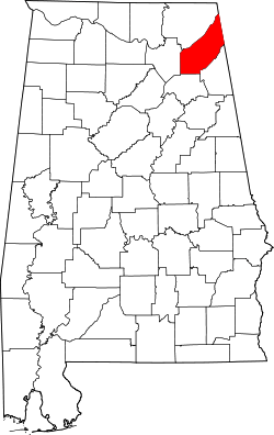 |
| Elmore County | 051 | Wetumpka | 29 | 1866 | Autauga, Coosa, Montgomery, and Tallapoosa counties | John Archer Elmore (1762–1834), Revolutionary War veteran | 128.32 | 79,303 | 618 sq mi (1,601 km2) |  |
| Escambia County | 053 | Brewton | 30 | 1868 | Baldwin and Conecuh counties | Escambia Creek, a tributary of the Conecuh River | 40.55 | 38,319 | 945 sq mi (2,448 km2) | 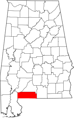 |
| Etowah County | 055 | Gadsden | 31 | 1866 | Blount, Calhoun, Cherokee, DeKalb, Marshall, and St. Clair counties (as Baine County) | Etowah Indian Mounds | 195.20 | 104,430 | 535 sq mi (1,386 km2) | 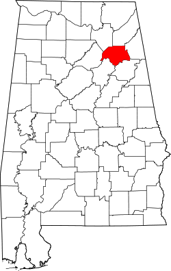 |
| Fayette County | 057 | Fayette | 32 | 1824 | Marion, Pickens, Tuscaloosa, and Walker counties | Marquis de La Fayette (1757–1834), Revolutionary War commander | 27.45 | 17,241 | 628 sq mi (1,627 km2) |  |
| Franklin County | 059 | Russellville | 33 | 1818 | چروکی territory | بن یمین فرینکلن (1706–1790), politician, diplomat, inventor, and publisher | 50.01 | 31,704 | 634 sq mi (1,642 km2) | 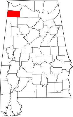 |
| Geneva County | 061 | Geneva | 34 | 1868 | Coffee, Dale, and Henry counties | Named after جنیوا (سٹی)، نیو یارک, the origin of several early settlers | 46.67 | 26,790 | 574 sq mi (1,487 km2) | 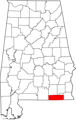 |
| Greene County | 063 | Eutaw | 35 | 1819 | Marengo and Tuscaloosa counties | Nathanael Greene (1742–1786), Revolutionary War general | 13.98 | 9,045 | 647 sq mi (1,676 km2) | 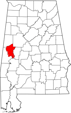 |
| Hale County | 065 | Greensboro | 36 | 1867 | Greene, Marengo, Perry, and Tuscaloosa counties | Stephen F. Hale (1816–1862), lieutenant colonel in Confederate States Army | 24.47 | 15,760 | 644 sq mi (1,668 km2) | 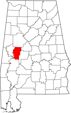 |
| Henry County | 067 | Abbeville | 37 | 1819 | Conecuh County | Patrick Henry (1736–1799), Revolutionary War patriot and Governor of Virginia | 30.79 | 17,302 | 562 sq mi (1,456 km2) | 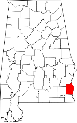 |
| Houston County | 069 | Dothan | 38 | 1903 | Dale, Geneva, and Henry counties | George S. Houston (1811–1879), 24th Governor of Alabama and ریاستہائے متحدہ ایوان نمائندگان | 175.08 | 101,547 | 580 sq mi (1,502 km2) | 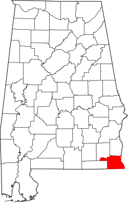 |
| Jackson County | 071 | Scottsboro | 39 | 1819 | چروکی territory | اینڈریو جیکسن (1767–1845), 7th U.S. President | 49.38 | 53,227 | 1,078 sq mi (2,792 km2) | 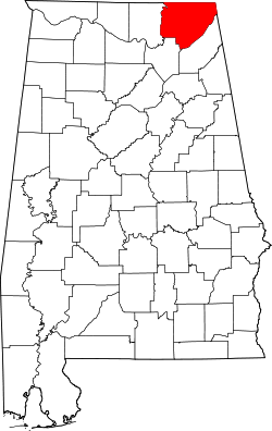 |
| Jefferson County | 073 | Birmingham | 1 | 1819 | Blount County | ٹامس جیفرسن (1743–1826), 3rd U.S. President | 592.68 | 658,466 | 1,111 sq mi (2,877 km2) | 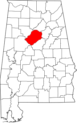 |
| Lamar County | 075 | Vernon | 40 | 1867 | Fayette and Marion counties (as Jones County) | Lucius Q. C. Lamar (1825–1893), U.S. Supreme Court justice | 24.07 | 14,564 | 605 sq mi (1,567 km2) | 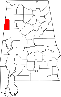 |
| Lauderdale County | 077 | Florence | 41 | 1818 | چروکی and Chickasaw territories | James Lauderdale (1780–1814), Colonel in War of 1812 | 138.79 | 92,709 | 668 sq mi (1,730 km2) | 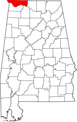 |
| Lawrence County | 079 | Moulton | 42 | 1818 | چروکی territory | James Lawrence (1781–1813), naval officer in War of 1812 | 49.69 | 34,339 | 691 sq mi (1,790 km2) | 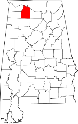 |
| Lee County | 081 | Opelika | 43 | 1866 | Chambers, Macon, Russell, and Tallapoosa counties | Robert E. Lee (1807–1870), Commander of the Confederate States Army | 230.67 | 140,247 | 608 sq mi (1,575 km2) | 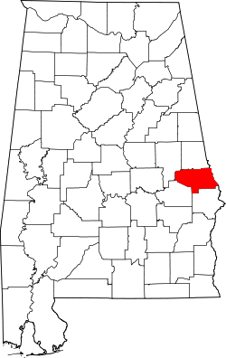 |
| Limestone County | 083 | Athens | 44 | 1818 | Elk and Madison counties | Limestone Creek, named for local geological deposits | 147.83 | 82,782 | 560 sq mi (1,450 km2) | 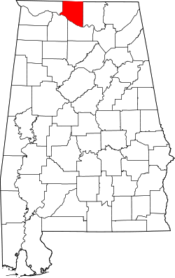 |
| Lowndes County | 085 | Hayneville | 45 | 1830 | Butler, Dallas, and Montgomery counties | William Lowndes (1782–1822), ریاستہائے متحدہ ایوان نمائندگان from جنوبی کیرولائنا | 15.78 | 11,299 | 716 sq mi (1,854 km2) | 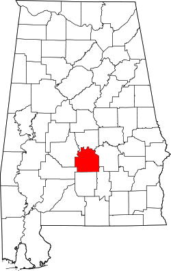 |
| Macon County | 087 | Tuskegee | 46 | 1832 | Montgomery County | Nathaniel Macon (1758–1837), U.S. legislator from شمالی کیرولائنا | 35.22 | 21,452 | 609 sq mi (1,577 km2) | 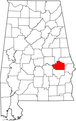 |
| Madison County | 089 | Huntsville | 47 | 1808 | چروکی and Chickasaw territories | جیمز میڈیسن (1751–1836), 4th U.S. President | 417.47 | 334,811 | 802 sq mi (2,077 km2) | 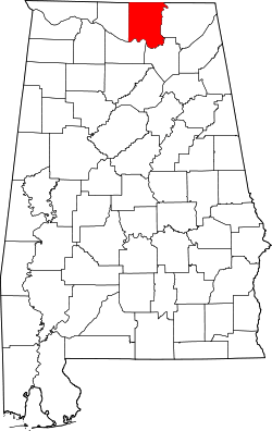 |
| Marengo County | 091 | Linden | 48 | 1818 | Choctaw territory | Battle of Marengo | 21.52 | 21,027 | 977 sq mi (2,530 km2) | 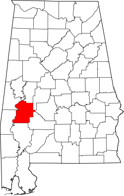 |
| Marion County | 093 | Hamilton | 49 | 1818 | Tuscaloosa County | Francis Marion (1732–1795), military leader in امریکی جنگ انقلاب | 41.48 | 30,776 | 742 sq mi (1,922 km2) | 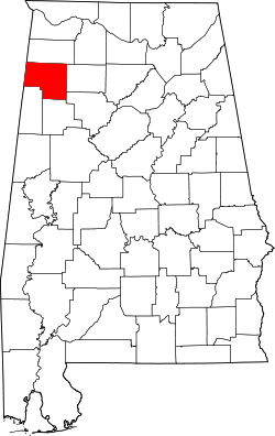 |
| Marshall County | 095 | Guntersville | 50 | 1836 | Blount and Jackson counties and چروکی territory | John Marshall (1755–1835), Chief Justice of the United States 1801–1835 | 164.34 | 93,019 | 566 sq mi (1,466 km2) | 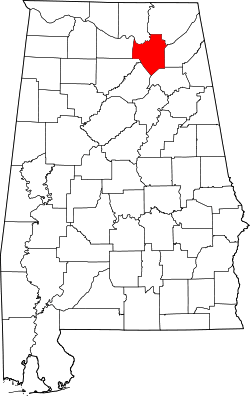 |
| Mobile County | 097 | Mobile | 2 | 1812 | Mobile District of West Florida after annexation into Mississippi Territory | Mobile Bay, on which county is located, and which is itself named after the Maubila tribe of Native Americans | 336.04 | 412,992 | 1,229 sq mi (3,183 km2) | 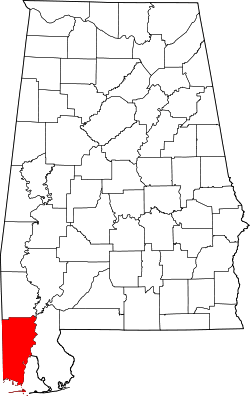 |
| Monroe County | 099 | Monroeville | 51 | 1815 | Creek territory | جیمز مونرو (1758–1831), 5th U.S. President | 22.48 | 23,068 | 1,026 sq mi (2,657 km2) | 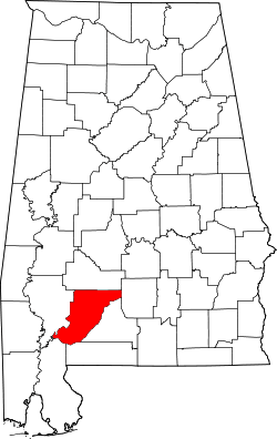 |
| Montgomery County | 101 | Montgomery | 3 | 1816 | Monroe County | Lemuel P. Montgomery (1786–1814), Major in Creek War | 292.55 | 229,363 | 784 sq mi (2,031 km2) | 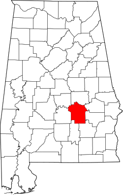 |
| Morgan County | 103 | Decatur | 52 | 1818 | چروکی territory (as Cotaco County) | Daniel Morgan (1736–1802), ریاستہائے متحدہ ایوان نمائندگان | 206.37 | 119,490 | 579 sq mi (1,500 km2) |  |
| Perry County | 105 | Marion | 53 | 1819 | Cahawba, Dallas, Marengo, and Tuscaloosa counties | Oliver Hazard Perry (1795–1819), naval officer in War of 1812 | 14.71 | 10,591 | 720 sq mi (1,865 km2) | 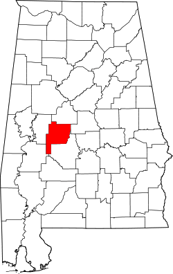 |
| Pickens County | 107 | Carrollton | 54 | 1820 | Tuscaloosa County | Andrew Pickens (1739–1817), General in the Revolutionary War | 22.41 | 19,746 | 881 sq mi (2,282 km2) | 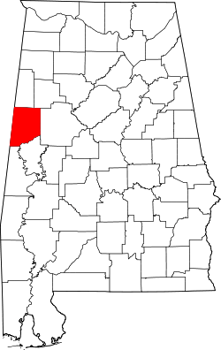 |
| Pike County | 109 | Troy | 55 | 1821 | Henry and Montgomery counties | Zebulon Pike (1779–1813), explorer and officer in War of 1812 | 48.96 | 32,899 | 672 sq mi (1,740 km2) | 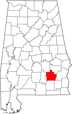 |
| Randolph County | 111 | Wedowee | 56 | 1832 | St. Clair and Shelby counties | John Randolph (1773–1833), ریاستہائے متحدہ سینٹ from ورجینیا | 39.44 | 22,913 | 581 sq mi (1,505 km2) | 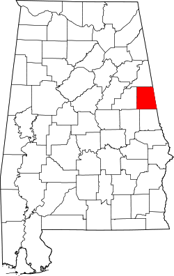 |
| Russell County | 113 | Phenix City | 57 | 1832 | Barbour, Bullock, Lee and Macon counties | Gilbert C. Russell (1782-1861), officer in Creek War | 82.60 | 52,947 | 641 sq mi (1,660 km2) | 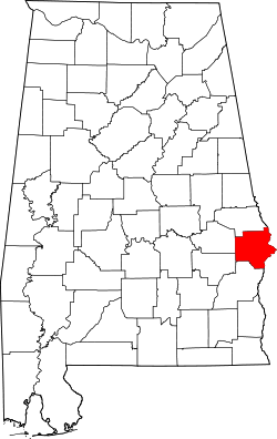 |
| St. Clair County | 115 | Ashville and Pell City | 59 | 1818 | Shelby County | Arthur St. Clair (1736–1818), President of Continental Congress | 132.27 | 83,593 | 632 sq mi (1,637 km2) |  |
| Shelby County | 117 | Columbiana | 58 | 1818 | Montgomery County | Isaac Shelby (1750–1826), Governor of Kentucky | 248.52 | 195,085 | 785 sq mi (2,033 km2) | 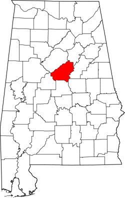 |
| Sumter County | 119 | Livingston | 60 | 1832 | Choctaw territory | Thomas Sumter (1734–1832), U.S. Congressman from جنوبی کیرولائنا | 15.22 | 13,763 | 904 sq mi (2,341 km2) | 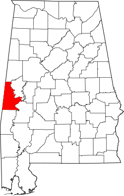 |
| Talladega County | 121 | Talladega | 61 | 1832 | St. Clair and Shelby counties | Talatigi, Creek Indian name for the county seat, meaning "border town" | 111.66 | 82,291 | 737 sq mi (1,909 km2) |  |
| Tallapoosa County | 123 | Dadeville | 62 | 1832 | Montgomery and Shelby counties | Tallapoosa River | 58.04 | 41,616 | 717 sq mi (1,857 km2) |  |
| Tuscaloosa County | 125 | Tuscaloosa | 63 | 1818 | Montgomery County and Choctaw territory | Iroquoian name for the Black Warrior River | 147.24 | 194,656 | 1,322 sq mi (3,424 km2) | 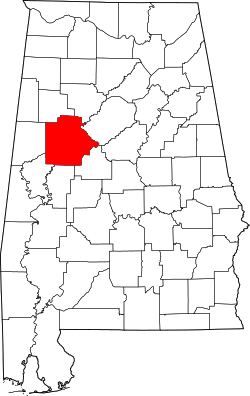 |
| Walker County | 127 | Jasper | 64 | 1823 | Blount, Jefferson, and Tuscaloosa counties | John Williams Walker (1783–1823), ریاستہائے متحدہ سینٹ from الاباما | 84.73 | 67,023 | 791 sq mi (2,049 km2) | 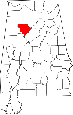 |
| Washington County | 129 | Chatom | 65 | 1800 | Adams and Pickering counties of Mississippi Territory | جارج واشنگٹن (1732–1799), 1st U.S. President | 16.28 | 17,581 | 1,080 sq mi (2,797 km2) | 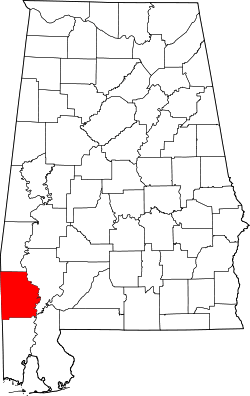 |
| Wilcox County | 131 | Camden | 66 | 1819 | Dallas and Monroe counties | Joseph M. Wilcox (1790–1814), lieutenant in Creek War | 13.14 | 11,670 | 888 sq mi (2,300 km2) | 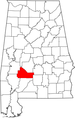 |
| Winston County | 133 | Double Springs | 67 | 1850 | Walker County (as Hancock County) | John A. Winston (1812–1871), 15th Governor of Alabama | 40.10 | 24,484 | 613 sq mi (1,588 km2) | 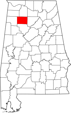 |
حوالہ جات
- "Find A County"۔ National Association of Counties۔ مورخہ 24 دسمبر 2018 کو اصل سے آرکائیو شدہ۔ اخذ شدہ بتاریخ 2012-04-07۔
- "EPA County FIPS Code Listing"۔ EPA.gov۔ مورخہ 24 دسمبر 2018 کو اصل سے آرکائیو شدہ۔ اخذ شدہ بتاریخ 2008-02-23۔
- National Association of Counties۔ "NACo - Find a county"۔ مورخہ 2008-03-09 کو اصل سے آرکائیو شدہ۔ اخذ شدہ بتاریخ 2008-04-30۔
- Nicholson, David۔ "Alabama County Codes"۔ License Plates of North America, 1969–present۔ مورخہ 24 دسمبر 2018 کو اصل سے آرکائیو شدہ۔ اخذ شدہ بتاریخ 2009-05-25۔
- Thomas McAdory Owen؛ Owen, Marie Bankhead۔ History of Alabama and Dictionary of Alabama Biography۔ Chicago: S.J. Clarke Publishing Company۔
- "Alabama Counties"۔ Alabama Department of Archives and History۔ مورخہ 24 دسمبر 2018 کو اصل سے آرکائیو شدہ۔ اخذ شدہ بتاریخ 2009-06-01۔
- Coffee County, Alabama۔ "History of Coffee County"۔ مورخہ 24 دسمبر 2018 کو اصل سے آرکائیو شدہ۔ اخذ شدہ بتاریخ 2011-08-19۔
مونٹگمری، الاباما (دارالحکومت) | |
| موضوعات |
|
| معاشرہ |
|
| علاقہ جات |
|
| نباتیہ وحیوانیہ |
|
| فہرست الاباما کے شہر اور ٹاؤن | |
| میٹروپولیٹن |
|
| فہرست الاباما کی کاؤنٹیاں |
|
This article is issued from
Wikipedia.
The text is licensed under Creative
Commons - Attribution - Sharealike.
Additional terms may apply for the media files.