ریڈ لائن (لواس)
ریڈ لائن (انگریزی: Red Line) (آئرش: Líne Dhearg[1]) ڈبلن کے لواس ہلکی ریل نظام کی دو لائنوں میں سے ایک ہے۔
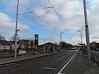
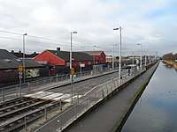
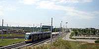
روٹ
| تصویر | نام آئرش نام |
برابچ | زون | مقام | ٹرانسپورٹ انٹرچینج | خدمت |
|---|---|---|---|---|---|---|
 |
The Point Iosta na Rinne |
Docklands (Terminus) | Red 1 | Mayor Street Upper 53.348338°N 6.229195°W |
3Arena | |
 |
Spencer Dock Duga Spencer |
Docklands | Red 1 | Mayor Street Upper 53.348806°N 6.237134°W |
کنونشن سینٹر ڈبلن | |
| Mayor Square — NCI Cearnóg an Mhéara — CNÉ |
Docklands | Red 1 | Mayor Street Lower 53.349203°N 6.243276°W |
Taxi rank |
نیشنل کالج آف آئرلینڈ | |
| George's Dock Duga Sheoirse |
Docklands | Red 1 / Central City Centre (off peak) |
George's Dock 53.349440°N 6.247562°W |
Jeanie Johnston | ||
 |
Connolly Conghaile |
Connolly (Terminus) | Red 1 / Central City Centre (off peak) |
Amiens Street 53.351025°N 6.250121°W |
نیشنل کالج آف آئرلینڈ | |
.jpg) |
Busáras | Main line | Red 1 / Central City Centre (off peak) |
Store Street 53.350100°N 6.251607°W |
Busáras کسٹم ہاؤس انٹرنیشنل فائنینشل سروسز سینٹر | |
 |
Abbey Street Sráid na Mainistreach |
Main line | Central City Centre (off peak) |
Lower Abbey Street 53.348556°N 6.258490°W |
او کونل اسٹریٹ، او کونل پل، Abbey Street Abbey Theatre ٹرنیٹی کالج، ڈبلن | |
| Jervis | Main line | Central | Upper Abbey Street 53.347711°N 6.265265°W |
ہینری اسٹریٹ، ڈبلن، پارنیل اسٹریٹ، ٹیمپل بار، ڈبلن Jervis Shopping Centre St. Mary's Abbey | ||
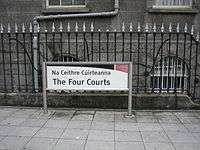 |
The Four Courts Na Ceithre Cúirteanna |
Main line | Central City Centre (off peak) |
between Greek Street and Church Street 53.346846°N 6.273676°W |
فور کورٹس ووڈ کی ڈبلن سٹی کونسل St. Audoen's Church St. Michan's Church | |
.jpg) |
Smithfield Margadh na Feirme |
Main line | Central | Phoenix Street North 53.347114°N 6.278054°W |
Old Jameson Distillery Smithfield لائٹ ہاؤس سنیما | |
.jpg) |
Museum Músaem |
Main line | Central | Croppies' Acre 53.347880°N 6.286927°W |
National Museum of Ireland – Decorative Arts and History Arbour Hill Prison | |
_at_Heuston_station%2C_June_2005.jpg) |
Heuston | Main line | Central / Red 2 | ہیوسٹن ریلوے اسٹیشن 53.346666°N 6.291811°W |
St. Patrick's Hospital فینکس پارک | |
 |
James's Ospidéal San Séamas |
Main line | Red 2 | James's Street 53.341763°N 6.293361°W |
نیشنل کالج آف آرٹ اور ڈیزائن St. James's Hospital Guinness Storehouse | |
 |
Fatima | Main line | Red 2 | James's Walk 53.338450°N 6.292809°W |
Dolphin's Barn، The Coombe دی لبرٹیز، ڈبلن Coombe Women & Infants University Hospital | |
 |
Rialto | Main line | Red 2 | James's Walk 53.337909°N 6.297401°W |
Rialto | |
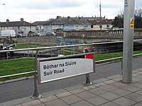 |
Suir Road Bóthar na Siúire |
Main line | Red 2/3 | Davitt Road 53.336643°N 6.307255°W |
Inchicore، Kilmainham رچمنڈ پارک (فٹ بال گراؤنڈ) Good Counsel GAA Inchicore College of Further Education آئیرش میوزیم آف ماڈرن ارٹ Royal Hospital Kilmainham Kilmainham Gaol | |
 |
Goldenbridge An Droichead Órga |
Main line | Red 3 | Davitt Road 53.335916°N 6.313301°W |
||
 |
Drimnagh Droimeanach |
Main line | Red 3 | Davitt Road 53.335349°N 6.318290°W |
Our Lady's Children's Hospital, Crumlin Richmond Barracks Goldenbridge Cemetery | |
 |
Blackhorse An Capall Dubh |
Main line | Red 3 | Mayor Street Upper 53.334273°N 6.327543°W |
Goldenbridge Industrial Estate Lansdowne Valley Park Westlink Industrial Estate | |
| Bluebell An Cloigín Gorm |
Main line | Red 3 | Naas Road 53.329327°N 6.333895°W |
Drimnagh Drimnagh Castle Lansdowne Valley Park | ||
 |
Kylemore An Chill Mhór |
Main line | Red 3 | Naas Road 53.326639°N 6.343814°W |
واکنز ٹاؤن St James Gaels GAA Kylemore College | |
 |
Red Cow An Bhó Dhearg |
Main line | Red 3 | Red Cow interchange 53.316307°N 6.370167°W |
Ballymount Park | |
 |
Kingswood Coill an Rí |
Main line | Red 3 | R838 53.303638°N 6.365452°W |
Tallaght Medical Centre | |
| Belgard | Main line | Red 3/4 | Old Belgard Road 53.299256°N 6.375135°W |
Belgard، Kilnamanagh Kilnamanagh Shopping Centre | ||
| Fettercairn Fothair Chardain |
Saggart line | Red 4 | Katherine Tynan Road 53.293325°N 6.395937°W |
Fettercairn St Marks GAA Saint Anne's School | ||
| Cheeverstown Baile an tSíbhrigh |
Saggart line | Red 4 | کاؤنٹی ڈبلن کے ٹاؤن لینڈز کی فہرست 53.291045°N 6.406500°W |
Luas Park + Ride |
||
| Citywest Campus Campas Gnó Iarthar na Cathrach |
Saggart line | Red 4 | Citywest 53.288460°N 6.417647°W |
Luas Park + Ride |
Citywest | |
| Fortunestown Baile Uí Fhoirtcheirn |
Saggart line | Red 4 | تآلا 53.284253°N 6.424782°W |
تآلا Citywest Shopping Centre | ||
| Saggart Teach Sagard |
Saggart line (Terminus) | Red 4 | سگگارٹ 53.284785°N 6.437801°W |
سگگارٹ، وائیٹ چرچ، کاؤنٹی ڈبلن، بالڈونل، ڈبلن Citywest Educate Together N.S. Citywest Golf Course کیسمینٹ ایروڈروم | ||
 |
Cookstown Baile an Chócaigh |
Tallaght line | Red 4 | Cookstown Way 53.293305°N 6.384044°W |
Cookstown St. Mark's Community School | |
 |
Hospital Ospidéal Tamhlachta |
Tallaght line | Red 4 | Cookstown Way 53.289277°N 6.379002°W |
Adelaide and Meath Hospital | |
 |
Tallaght Tamhlacht |
Tallaght line (Terminus) | Red 4 | Hibernian Industrial Estate 53.287424°N 6.374581°W |
Luas Park + Ride Dualway Local Bus Services |
تآلا انسٹی ٹیوٹ آف ٹیکنالوجی، تآلا تآلا اسٹیڈیم Civic Theatre The Square Shopping Centre |
مزید دیکھیے
بیرونی روابط
| ویکی کومنز پر ریڈ لائن (لواس) سے متعلق سمعی و بصری مواد ملاحظہ کریں۔ |
This article is issued from
Wikipedia.
The text is licensed under Creative
Commons - Attribution - Sharealike.
Additional terms may apply for the media files.