ஓலந்து தீவுகள்
ஓலந்து (சுவீடிய மொழி ஒலிப்பு IPA: ['oːland]) அல்லது பொதுவாக ஓலந்து தீவுகள் பால்டிக் கடலில் உள்ள ஒரு தீவுக்கூட்டமாகும். இது போதியா குடாவின் வாயிலில் அமைந்துள்ளது. இது பின்லாந்தின் சுவீடிய மொழி பேசும் சுயாட்சி மாகாணமாகும்.
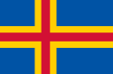
| ஓலந்து தீவுகள் Landskapet Åland Ahvenanmaan maakunta |
||||||
|---|---|---|---|---|---|---|
|
||||||
| குறிக்கோள்: கிடையாது | ||||||
| நாட்டுப்பண்: W:Ålänningens sång | ||||||
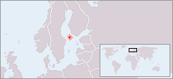 Location of ஓலந்தின் |
||||||
| தலைநகரம் | மரியம்ன் 60°7′N 19°54′E | |||||
| பெரிய நகர் | தலைநகர் | |||||
| ஆட்சி மொழி(கள்) | சுவீடிய மொழி | |||||
| அரசாங்கம் | சுயாட்சி மாகாணம் | |||||
| • | ஆளுனர் | பீட்டர் லின்பேக்1 | ||||
| • | முதல்வர் | ரொஜர் நோர்ட்லுட் | ||||
| சுயாட்சி | ||||||
| • | கோரல் | 1920 | ||||
| • | அங்கீகாரம் | 19212 | ||||
| பரப்பு | ||||||
| • | மொத்தம் | 13,517 கிமீ2 (தரப்படுத்தப்படவில்லை) 5,267 சதுர மைல் |
||||
| • | நீர் (%) | 89 | ||||
| மக்கள் தொகை | ||||||
| • | 2005 கணக்கெடுப்பு | 26,711 | ||||
| நாணயம் | ஐரோ (€)4 (EUR) | |||||
| நேர வலயம் | EET (ஒ.அ.நே+2) | |||||
| • | கோடை (ப.சே) | EEST (ஒ.அ.நே+3) | ||||
| அழைப்புக்குறி | 358 (பிரதேச இலக்கம் 18) | |||||
| இணையக் குறி | .ax5 | |||||
| 1. | The governor is an administrative post appointed by the Government of Finland, and does not have any authority over the autonomous Government of Åland. | |||||
| 2. | Settled by the உலக நாடுகள் சங்கம் following the Åland crisis. | |||||
| 3. | Åland held a separate referendum and then joined at the same time as the rest of Finland. | |||||
| 4. | Until 1999, the Finnish mark. | |||||
| 5. | Replacing .aland.fi from ஆகஸ்டு 2006.The .eu domain is also used, as it is shared with Finland and the rest of ஐரோப்பிய ஒன்றியம் member states. | |||||

இத்தீவுக்கூட்டங்களில் பஸ்டா ஓலந்து மிக முக்கிய தீவாகும். இங்கு மொத்த மக்கள் தொகையில் 90% மக்கள் வாழ்கிறார்கள்[1]. இதைத் தவிர கிழக்கில் மேலும் 6,500 பாறைத்தீவுகளைக் கொண்டுள்ளது[2]. பஸ்டா எலந்து தீவு சுவீடனில் இருந்து 40 கி.மீ. அகலமான கடலால் பிரிக்கப்பட்டுள்ளது. எலந்து ஒரு குறுகிய நில எல்லையைக் கொண்டுள்ளது.[3]; இது மார்கெட் தீவில் சுவீடன் நாட்டுடன் அமைந்த எல்லையாகும்.
மேற்கோள்கள்
- "The Aland Islands" (9 May 2012). மூல முகவரியிலிருந்து 9 May 2012 அன்று பரணிடப்பட்டது. பார்த்த நாள் 26 October 2017.
- Scheffel, Richard L., தொகுப்பாசிரியர் (1980). Natural Wonders of the World. United States of America: Reader's Digest Association, Inc. பக். 3. பன்னாட்டுத் தரப்புத்தக எண்:0-89577-087-3.
- an account of the border on Märket, and how it was redrawn in 1985, appears in Hidden Europe Magazine, 11 (November 2006) pp. 26-29 ISSN 1860-6318
புற இணைப்புகள்
- Wikimedia Atlas of Åland
- Åland official site (ஆங்கிலம்)
- Government of Åland (சுவீடியம்)
- B7 Baltic Islands Network
- The example of Åland, autonomy as a minor protector The Åland example: autonomy protects a minority
- Ålandstidningen (local newspaper)
This article is issued from
Wikipedia.
The text is licensed under Creative
Commons - Attribution - Sharealike.
Additional terms may apply for the media files.