মার্শাল দ্বীপপুঞ্জ
প্রজাতন্ত্রী মার্শাল দ্বীপপুঞ্জ (মার্শালীয় Aolepān Aorōkin M̧ajeļ আয়্লেপ্যান্ আয়্রেকিন্ মায়্তেয়াল্, ইংরেজি Republic of the Marshall Islands রিপাব্লিক অভ দ্য মার্শাল আইল্যান্ডস) প্রশান্ত মহাসাগরের একাধিক দ্বীপের সমন্বয়ে গঠিত একটি দ্বীপ রাষ্ট্র। এটি ওশেনিয়া অঞ্চলে অবস্থিত।
| Republic of the Marshall Islands প্রজাতন্ত্রী মার্শাল দ্বীপপুঞ্জ Aolepān Aorōkin M̧ajeļ Republic of the Marshall Islands |
||||||
|---|---|---|---|---|---|---|
|
||||||
| নীতিবাক্য: "Jepilpilin ke ejukaan" "Accomplishment through joint effort" |
||||||
| জাতীয় সঙ্গীত: "Forever Marshall Islands" | ||||||
_(Polynesia_centered).svg.png) Marshall Islands অবস্থান |
||||||
_-_MHL_-_UNOCHA.svg.png) Marshall Islands অবস্থান |
||||||
| রাজধানী | Majuro[1] ৭°৭′ উত্তর ১৭১°৪′ পূর্ব | |||||
| বৃহত্তম শহর | capital | |||||
| সরকারি ভাষা |
|
|||||
| জাতিগোষ্ঠী(2006) |
|
|||||
| জাতীয়তাসূচক বিশেষণ | Marshallese | |||||
| সরকার | Unitary parliamentary republic | |||||
| • | President | Christopher Loeak | ||||
| আইন-সভা | Nitijela | |||||
| Independence | ||||||
| • | Self-government | 1979 | ||||
| • | Compact of Free Association | October 21, 1986 | ||||
| • | মোট | ১৮১ কিমি২ (213th) ৭০ বর্গ মাইল |
||||
| • | জল/পানি (%) | n/a (negligible) | ||||
| জনসংখ্যা | ||||||
| • | 2009 আনুমানিক | 68,000[2] (205th) | ||||
| • | 2003 আদমশুমারি | 56,429 | ||||
| • | ঘনত্ব | 342.5/কিমি২ (28th) ৮৮৫.৭/বর্গ মাইল |
||||
| মোট দেশজ উৎপাদন (ক্রয়ক্ষমতা সমতা) |
2001 আনুমানিক | |||||
| • | মোট | $115 million (220th) | ||||
| • | মাথা পিছু | $2,900a (195th) | ||||
| মুদ্রা | United States dollar (USD) | |||||
| সময় অঞ্চল | MHT (ইউটিসি+12) | |||||
| গাড়ী চালনার দিক | right | |||||
| কলিং কোড | +692 | |||||
| ইন্টারনেট টিএলডি | .mh | |||||
| ক. | 2005 estimate. | |||||


ইতিহাস
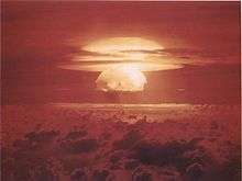
Mushroom cloud from the largest nuclear test the United States ever conducted, Castle Bravo.
২য় শতক থেকেই মার্শাল দ্বীপপুঞ্জে জনবসতির নির্দশন পাওয়া যায়। ১৯৪৬ সাল থেকে ১৯৫৮ সাল পর্যন্ত আমেরিকা ৬৭বার পারমাণবিক পরীক্ষা চালায় এই দ্বীপে।[3] ১৯৭৯ সালে মার্শাল দ্বীপপুঞ্জের সরকার গঠিত হয়।
রাজনীতি
প্রশাসনিক অঞ্চলসমূহ
ভূগোল
অর্থনীতি
জনসংখ্যা
সংস্কৃতি
আরও দেখুন
তথ্যসূত্র
- The largest cities in Marshall Islands, ranked by population. population.mongabay.com. Retrieved on May 25, 2012.
- Department of Economic and Social Affairs Population Division (২০০৯)। "World Population Prospects, Table A.1" (PDF)। 2008 revision। United Nations। সংগ্রহের তারিখ মার্চ ১২, ২০০৯।
- "Nuclear Weapons Test Map", Public Broadcasting Service
বহিঃসংযোগ
ওশেনিয়ার সার্বভৌম রাষ্ট্র ও নির্ভরশীল অঞ্চলসমূহ | |||||||||||
|---|---|---|---|---|---|---|---|---|---|---|---|
| সার্বভৌম রাষ্ট্রসমূহ |
| .svg.png) | |||||||||
| নির্ভরশীল অঞ্চলসমূহ এবং অন্যান্য অঞ্চলসমূহ |
| ||||||||||
This article is issued from
Wikipedia.
The text is licensed under Creative
Commons - Attribution - Sharealike.
Additional terms may apply for the media files.