Initiating an Advisory
Identify the Situation and Collect Facts
Drinking water advisories are issued for reasons identified in federal or state regulations or by decisions made by the water system. The situation and characteristics of the contaminant(s) of concern determine what type of advisory to distribute:
Essential Information
- Who you are
- What action customers should take
- What event occurred and a description of the problem
- Where it occurred
- When it occurred
- Expected duration
- Why it happened
- Who is affected
- Basic information about the water system
- Current actions being taken
- Requested agency responses
- What public notice is required when appropriate
- Where to get more information
- Informational
- Boil Water
- Do Not Drink
- Do Not Use
Use the Essential Information list to collect data and develop communication materials.
Notify Your Drinking Water Primacy Agency
Each state that has primacy specifies particular mechanisms for state notification. Be familiar with your water system’s protocols for notifying your primacy agency. See Appendix C: Online Resources, Primacy Agency.
![]()
Identify the Geographic Boundaries
Boundaries
Maps Help Define The Area Affected
When possible, use maps and brief descriptions of the boundaries of the area affected. Maintain and update maps of the water service area. Maps can be sent out as printed or electronic versions. Make sure the maps:
- Are presented at a legible scale with legible fonts
- Are uncluttered
- Reflect commonplace names and reference points
- Have crisp lines
- Are easy to read
Descriptions
Clearly communicating the boundaries of affected areas also requires careful consideration of verbal descriptions so that spokespersons, radio, and other media can briefly but accurately depict the service area affected.
A key component of a drinking water advisory is to communicate clearly the area affected. Many customers do not know which water system provides their service and broadcast media usually reach a large audience beyond the affected area.
Clearly describe the boundaries of the affected area using street names, place names, building identification information (e.g., building numbers, unit numbers, wings, etc.) and well known reference points.
Maps
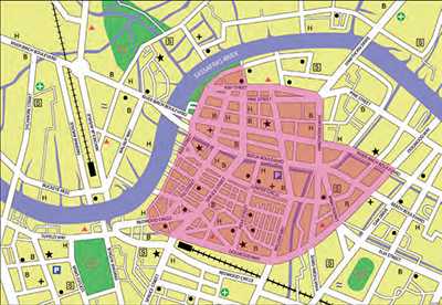
Maps help illustrate the affected area. Water systems can generate maps using internal or online mapping tools (e.g., geographic information system [GIS]). These maps can be posted on agency websites, or distributed electronically or as printed material. Update the map as the situation changes.
Figure 5: Example of a Simple Map to Designate an Area Affected by a Drinking Water Advisory

Notify Your Internal Staff and External Partners
Activate your internal communication SOP. Use information collected to brief staff. Depending on the situation, also brief your partners:
- Wholesale, consecutive, and neighboring water systems
- Public health department
- Critical customers (see Critical Customer Checklist [DOCX - 1 page]
 to assist in identifying at-risk populations served by a water system)
 - Public officials
- Emergency management
- Community organizations
- Businesses, childcare facilities, correctional facilities, food service, healthcare providers and facilities, and schools
Provide the Call Center Data Checklist [DOCX - 1 page]
![]() to call center or customer service staff and partners.
to call center or customer service staff and partners.
- Page last reviewed: March 29, 2017
- Page last updated: March 29, 2017
- Content source:


 ShareCompartir