

Map Details - GIS for monitoring the spatial spread of meningitis outbreaks and assessing spatio-temporal relationships of Neisseria meningitidis and climate factors in the Meningitis Belt of Africa
 ShareCompartir
GIS for monitoring the spatial spread of meningitis outbreaks and assessing spatio-temporal relationships of Neisseria meningitidis and climate factors in the Meningitis Belt of Africa
Description
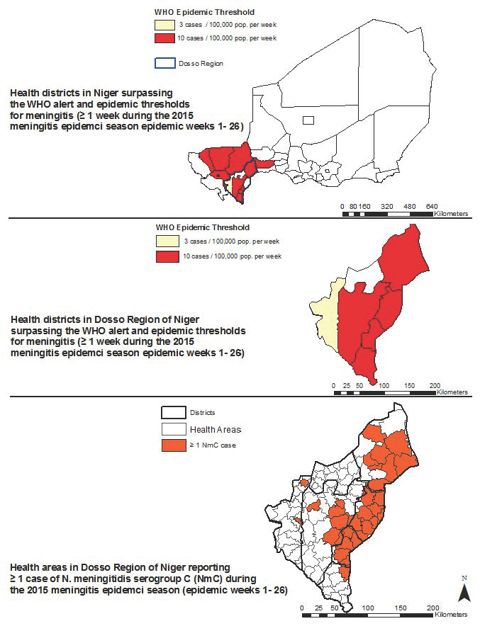
In the meningitis belt of sub-Saharan Africa, devastating meningitis epidemics have historically been due to Neisseria meningitidis serogroup A. Prior to the unprecedented 2015 Neisseria meningitidis serogroup C (NmC) epidemic in Niger that resulted in over 8,500 suspected cases and 500 deaths across 12 health districts, NmC epidemics have been rarely reported. In contrast to this large-scale NmC epidemic in Niger, prior epidemics have been relatively small and localized.
Although meningitis epidemics in Africa have been associated with the Harmattan winds, which are characterized by high surface dust concentrations, low humidity levels and high temperatures, the factors that contributed to the occurrence of this first large-scale NmC epidemic as well as its spatial and temporal evolution are not yet well characterized.
The Meningitis and Vaccine Preventable Diseases Branch at CDC in collaboration with the Centre de Recherche Médicale et Sanitaire, the Niger Ministry of Health, and the National Oceanic and Atmospheric Administration is using geospatial analyses to understand the epidemiological, spatial and temporal characteristics of NmC as well as the relationship between its incidence and climate factors in the Dosso region of Niger at the health area (aires de santé) scale from 2002 to 2015. Specifically, cluster analysis, spatio-temporal methods such as the Kulldorff Scan Test and negative binomial regression are being used. This work will help inform vaccination and other outbreak response strategies and contribute to efforts towards the prediction of future outbreaks.
Software used:
ArcGIS
Data sources:
Nov 2015
Key words:
GIS, Meningitis, Africa
Location:
Niger
Health Issue:
Immunization and Respiratory Diseases
Author / Contact Information:
Sarah Meyer (vif6@cdc.gov) NCIRD / DBD / MVPDB
Ryan Novak (bnk4@cdc.gov) NCIRD / DBD / MVPDB
Citation:
Diallo, Alpha Oumar; Meyer, Sarah A. ; Novak, Ryan T. Spatial distribution of an emerging epidemic strain of Neisseria meningitidis serogroup C in Niger, 2015, March 30, 2016 .
- Page last reviewed: April 11, 2016
- Page last updated: April 11, 2016
- Content source: