

Map Details - Food Deserts in Texas
 ShareCompartir
Impact Statement
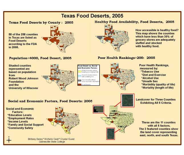
Of Texas’ 258 counties, 58 counties are considered Food Deserts according to the USDA definition and criteria. The criteria include lack of availability of fresh produce and limited or no presence of large grocery stores (stores with four or more employees). The areas identified as Food Deserts were further analyzed based on health rankings, population below 4,000, and socio-economic rankings. Counties were displayed in subsequent maps based on negative impact of the examined social criteria and their position as a Food Desert. Finally, counties that exhibited negative social impact based on all examined categories and designated as Food Deserts were identified.
There are several areas within the United States that meet the USDA criteria and have been identified as Food Deserts. Texas was chosen for analysis based on its large area, varied topography, representation of a full spectrum of income levels and diverse ethnic presence. Further analysis is warranted to determine the impact of available public transportation, fast food chains, ethnic pockets, land use and hydrological analysis, and climate and weather patterns before making any meaningful assessments and conclusions.
Software Used
ArcGIS 9.3.1
Data Used
Robert Wood Johnson Foundation; Landsat 7; Albers Equal Area Projection.
Methods Used
Subsetting; Chloropleth; Remote Sensing.
Contact the Submitter of this Map
Crystal Guest; Brittany Bailey; Michelle Cash, Students in the Environmental Spatial Analysis, Environmental Studies majors, Gainesville State College
(678) 524-7435
924185249@gsc.edu
How to Cite this Map
Food Deserts in Texas; 2005 and Social Impacts Brittany Bailey; Michelle Cash; Crystal Guest, Institute for Environmental Spatial Analysis, Gainesville State College, [TODAY’S DATE].
- Page last reviewed: July 13, 2017
- Page last updated: July 13, 2017
- Content source: