

Map Details - Drive Times to Telestroke Sites, Montana
 ShareCompartir
Impact Statement
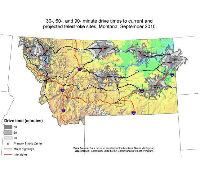
Developed in collaboration with the Montana Stroke Workgroup, this map illustrates the location of Montana’s stroke centers and drive time to current and projected telestroke sites that use the Stroke-Doc system.
Purpose
This map will be used when working with stroke partners to identify telestroke locations to improve stroke systems of care in Montana’s rural areas. Through a two-way interactive telestroke system, the Montana Cardiovascular Health Program and the Stroke Workgroup have improved the capacity of rural hospitals to conduct stroke consults with neurologists from stroke centers.
Software Used
ArcGIS 9.3.1
Data Used
Location of Stroke Centers and Telestroke sites were identified by the Montana Stroke Workgroup.
Methods Used
Network Analyst was used to determine drive times.
Contact the Submitter of this Map
Carrie Oser, Epidemiologist/Evaluator, Montana Department of Health and Human Services
406-444-4002
coser@mt.gov
How to Cite this Map
30-, 60-, and 90-minute drive times to current and projected telestroke sites, Montana, September 2010. Oser, Carrie MT DPHHS; McNamara, Michael MT DPHHS; Fogle, Crystelle MT DPHHS; Harwell, Todd MT DPHHS, Sep 19, 2014
- Page last reviewed: July 13, 2017
- Page last updated: July 13, 2017
- Content source: