

Map Details - Colorectal Cancer Incidence and Mortality Rates and Federally Qualified Health Centers, Illinois
 ShareCompartir
Impact Statement
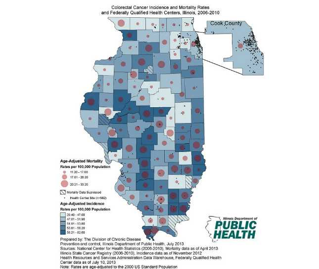
The map shows age-adjusted colorectal cancer incidence and mortality rates per 100,000 population for Illinois residents by county and the locations of Federally Qualified Health Centers (FQHC).
Findings/Purpose
The purposes of the map are to identify areas with increased colorectal cancer incidence and mortality rates, educate the public and stakeholders on the burden of colorectal cancer in Illinois, and assist with future collaborative efforts toward reducing the burden of colorectal cancer among Illinois residents. The main planned future collaborative effort this map is intended to assist with is to help the Illinois Cancer Partnership (ICP) and stakeholders identify FQHC’s that serve counties with high incidence and/or mortality rates in order to collaborate with the local FQHC in the ICP’s efforts to increase colorectal cancer screening and decrease colorectal cancer mortality in the most efficient and effective approach.
Software Used
ArcGIS Desktop 10 Service Pack 5
Data Used
National Center for Health Statistics (2006-2010) Mortality data as of April 2013; Illinois State Cancer Registry (2006-2010) Incidence data as of November 2012; U.S. Department of Health and Human Services, Health Resources and Services Administration Data Warehouse, Federally Qualified Health Center data as of July 10, 2013.
Methods Used
County-level colorectal cancer mortality rates from the National Center for Health Statistics and county-level colorectal cancer incidence rates from the Illinois State Cancer Registry were imported into ArcGIS to overlay colorectal cancer mortality rates onto colorectal cancer incidence rates. In addition, ArcGIS was used to geocode the locations of Federally Qualified Health Centers obtained through the U.S. Department of Health and Human Services. These geocoded locations were plotted overtop both incidence and mortality rates.
Contact the Submitter of this Map
Benjamin Arbise, Statistical Research Specialist , Illinois Department of Public Health, 525-535 West Jefferson Street, Springfield, Illinois 62761
(217) 558-2662
ben.arbise@illinois.gov
How to Cite this Map
Illinois Department of Public Health Office of Health Promotion Colorectal Cancer Age-Adjusted Incidence and Mortality Rates and Federally Qualified Health Centers Arbise, Benjamin MPH, CHES, Illinois Department of Public Health, Division of Chronic Disease Prevention and Control; Amerson, Nancy, MPH, Illinois Department of Public Health, Division of Chronic Disease Prevention & Control; Moody, Conny, MBA, Illinois Department of Public Health, Office of Health Promotion, [TODAY’S DATE].
- Page last reviewed: July 10, 2017
- Page last updated: July 10, 2017
- Content source: