نیدرلینڈز کے صوبے
نیدرلینڈز کے صوبے قومی حکومت اور مقامی بلدیات کے درمیان نیدرلینڈ میں انتظامی سطح کی نمائندگی کرتے ہیں۔
| نیدرلینڈز کے صوبے Provinces of the Netherlands Provincies van Nederland (ولندیزی) | |
|---|---|
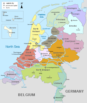 نیدرلینڈز کا نقشہ، صوبے کے مضامین سے منسلک | |
| زمرہ | وحدانی ریاست |
| مقام | نیدرلینڈز |
| تعداد | 12 صوبے |
| آبادی | 380,783 (زیلانت) – 3,575,451 (جنوبی ہولانت) |
| رقبہ | 559 مربع میل (1,450 کلومیٹر2) (اوتریخت) - 2,220 مربع میل (5,700 کلومیٹر2) (فریسلانت) |
| حکومت | صوبائی حکومت |
| ذیلی تقسیمات | بلدیہ |
صوبوں کی فہرست
| صوبہ | پرچم | نشان | دار الحکومت | سب سے بڑا شہر | شاہی کمشنر | رقبہ[1] | آبادی[2] | کثافت آبادی |
|---|---|---|---|---|---|---|---|---|
| درینتے | آسن | آسن | Jacques Tichelaar | 2,680 کلومیٹر2 (1,030 مربع میل) | 489,077 | 182/کلو میٹر2 (470/مربع میل) | ||
| فلیولانت | لیلیستات | المیرا | Leen Verbeek | 2,412 کلومیٹر2 (931 مربع میل) | 399,673 | 166/کلو میٹر2 (430/مربع میل) | ||
| فریسلانت[upper-alpha 1] | لیواردن | لیواردن | John Jorritsma | 5,749 کلومیٹر2 (2,220 مربع میل) | 646,354 | 112/کلو میٹر2 (290/مربع میل) | ||
| خیلدرلنت | ارنہم | نیمیخن | Clemens Cornielje | 5,136 کلومیٹر2 (1,983 مربع میل) | 2,019,296 | 393/کلو میٹر2 (1,020/مربع میل) | ||
| خرونیگین [upper-alpha 2] | خرونیگین | خرونیگین | Max van den Berg | 2,960 کلومیٹر2 (1,140 مربع میل) | 582,846 | 197/کلو میٹر2 (510/مربع میل) | ||
| لمبرخ | ماستریخت | ماستریخت | Theo Bovens[upper-alpha 3] | 2,209 کلومیٹر2 (853 مربع میل) | 1,121,021 | 508/کلو میٹر2 (1,320/مربع میل) | ||
| شمالی برابنت | سیرتوخنبوس[upper-alpha 4] | اینتہوون | Wim van de Donk | 5,082 کلومیٹر2 (1,962 مربع میل) | 2,479,045 | 488/کلو میٹر2 (1,260/مربع میل) | ||
| شمالی ہولانت | ہارلم[upper-alpha 5] | ایمسٹرڈیم[upper-alpha 5] | Johan Remkes | 4,091 کلومیٹر2 (1,580 مربع میل) | 2,739,032 | 670/کلو میٹر2 (1,700/مربع میل) | ||
| اوفریسل | زوولے | انسخدئے | Ank Bijleveld | 3,421 کلومیٹر2 (1,321 مربع میل) | 1,139,635 | 333/کلو میٹر2 (860/مربع میل) | ||
| جنوبی ہولانت | ہیگ[upper-alpha 6] | روتردم | Jaap Smit | 3,419 کلومیٹر2 (1,320 مربع میل) | 3,575,451 | 1,046/کلو میٹر2 (2,710/مربع میل) | ||
| اوتریخت | اوتریخت | اوتریخت | Willibrord van Beek | 1,449 کلومیٹر2 (559 مربع میل) | 1,252,233 | 864/کلو میٹر2 (2,240/مربع میل) | ||
| زیلانت | مڈلبرخ | مڈلبرخ | Han Polman | 2,933 کلومیٹر2 (1,132 مربع میل) | 380,783 | 130/کلو میٹر2 (340/مربع میل) |
حوالہ جات
- "Regionale kerncijfers Nederland"۔ CBS Statline (Dutch زبان میں)۔ CBS۔ 16 دسمبر 2013۔ مورخہ 26 دسمبر 2018 کو اصل سے آرکائیو شدہ۔ اخذ شدہ بتاریخ 19 دسمبر 2013۔ Unknown parameter
|trans_title=ignored (معاونت) - "Bevolkingsontwikkeling; regio per maand"۔ CBS Statline (Dutch زبان میں)۔ CBS۔ 29 نومبر 2013۔ مورخہ 26 دسمبر 2018 کو اصل سے آرکائیو شدہ۔ اخذ شدہ بتاریخ 18 دسمبر 2013۔ Unknown parameter
|trans_title=ignored (معاونت) - http://almanak.overheid.nl/categorie/31/Provincies/
- Andreas Daum۔ Berlin - Washington, 1800–2000 Capital Cities, Cultural Representation, and National Identities۔ Cambridge University Press۔ صفحات 13, 38۔ آئی ایس بی این 0521841178۔
Amsterdam is the statuary capital of the Netherlands, while the Dutch government resides in De Hague. (sic) (p. 13) The Netherlands' seat of government is The Hague but its capital is bustling Amsterdam, the national cultural center. (p. 38)
ملاحظات
- Friesland in Dutch; The official name Fryslân is in the West Frisian language[3]
- Grönnen in Gronings; Grinslân in West Frisian
- The function is titled governor in Limburg
- Also Den Bosch in Dutch.
- Amsterdam is the national capital of the Netherlands.[4] Haarlem is, however, the capital of the province in which both Amsterdam and Haarlem are situated.
- Den Haag or 's-Gravenhage in Dutch. The Dutch parliament and the Dutch government are located in The Hague along with the Supreme Court and the Council of State.[4]
This article is issued from
Wikipedia.
The text is licensed under Creative
Commons - Attribution - Sharealike.
Additional terms may apply for the media files.