ایسٹ ردرفورڈ، نیو جرسی
ایسٹ ردرفورڈ یا مشرقی ردرفورڈ (انگریزی: East Rutherford) برگن کاؤنٹی، نیو جرسی، ریاستہائے متحدہ امریکا میں ایک برو ہے۔
| مشرقی ردرفورڈ، نیو جرسی East Rutherford, New Jersey | ||
|---|---|---|
| برو | ||
| برو مشرقی ردرفورڈ | ||
 | ||
| ||
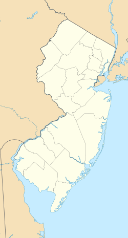
 Map highlighting East Rutherford's location within Bergen County. Inset: Bergen County's location within New Jersey | ||
 Census Bureau map of East Rutherford, New Jersey | ||
 مشرقی ردرفورڈ، نیو جرسی East Rutherford, New Jersey  مشرقی ردرفورڈ، نیو جرسی East Rutherford, New Jersey | ||
| متناسقات: 40.817097°N 74.085024°W[1][2] | ||
| ملک |
| |
| ریاست |
| |
| کاؤنٹی | برگن کاؤنٹی | |
| میونسپل کارپوریشن | اپریل 17, 1889 (as Boiling Springs township) | |
| Reincorporated | مارچ 28, 1894 (as East Rutherford) | |
| حکومت[3] | ||
| • قسم | برو | |
| • مجلس | برو کونسل | |
| • ناظم شہر | James L. Cassella (ریپبلکن پارٹی (ریاستہائے متحدہ)، term ends دسمبر 31, 2019)[4][5] | |
| • میونسپل کلرک | Danielle Lorenc[6] | |
| رقبہ[1] | ||
| • کل | 10.494 کلو میٹر2 (4.052 مربع میل) | |
| • زمینی | 9.606 کلو میٹر2 (3.709 مربع میل) | |
| • آبی | 0.889 کلو میٹر2 (0.343 مربع میل) 8.47% | |
| رقبہ درجہ |
295th of 566 in state 20th of 70 in county[1] | |
| بلندی[7] | 0.9 میل (3 فٹ) | |
| آبادی (ریاست ہائے متحدہ کی مردم شماری، 2010ء)[8][9][10] | ||
| • کل | 8,913 | |
| • تخمینہ (2016)[11] | 9,856 | |
| • درجہ |
258th of 566 in state 42nd of 70 in county[12] | |
| • کثافت | 927.9/کلو میٹر2 (2,403.2/مربع میل) | |
| • کثافت درجہ |
257th of 566 in state 52nd of 70 in county[12] | |
| منطقۂ وقت | مشرقی منطقۂ وقت (UTC−5) | |
| • گرما (گرمائی وقت) | مشرقی منطقۂ وقت (UTC−4) | |
| زپ کوڈ | 07073[13][14] | |
| ٹیلی فون کوڈ | 201 and 551 | |
| وفاقی اطلاعاتی عملکاری معیار | 3400319510[1][15][16] | |
| جغرافیائی ناموں کا نظام معلومات feature ID | 0885201[1][17] | |
| ویب سائٹ |
www | |
حوالہ جات
- 2010 Census Gazetteer Files: New Jersey County Subdivisions، ریاستہائے متحدہ مردم شماری بیورو۔ Accessed مئی 21, 2015.
- U.S. Gazetteer Files for 2000, 2010 and 2012–2016، ریاستہائے متحدہ مردم شماری بیورو۔ Accessed ستمبر 4, 2017.
- 2017 New Jersey Mayors Directory، New Jersey Department of Community Affairs۔ Accessed مئی 25, 2017.
- Borough Clerk's Office، Borough of East Rutherford. Accessed ستمبر 13, 2017.
- U.S. Geological Survey Geographic Names Information System: Borough of East Rutherford، جغرافیائی ناموں کا نظام معلومات۔ Accessed مارچ 5, 2013.
- DP-1 – Profile of General Population and Housing Characteristics: 2010 for East Rutherford borough, Bergen County, New Jersey، ریاستہائے متحدہ مردم شماری بیورو۔ Accessed جولائی 29, 2012.
- Profile of General Demographic Characteristics: 2010 for East Rutherford borough، New Jersey Department of Labor and Workforce Development۔ Accessed جولائی 29, 2012.
- GCT-PH1 Population, Housing Units, Area, and Density: 2010 – State -- County Subdivision from the 2010 Census Summary File 1 for New Jersey، ریاستہائے متحدہ مردم شماری بیورو۔ Accessed دسمبر 11, 2012.
- Look Up a ZIP Code for East Rutherford, NJ، United States Postal Service۔ Accessed ستمبر 12, 2011.
- ZIP Codes، State of نیو جرسی۔ Accessed اگست 28, 2013.
- American FactFinder، ریاستہائے متحدہ مردم شماری بیورو۔ Accessed ستمبر 4, 2014.
- Geographic Codes Lookup for New Jersey، Missouri Census Data Center. Accessed ستمبر 13, 2017.
- US Board on Geographic Names، United States Geological Survey۔ Accessed ستمبر 4, 2014.
بیرونی روابط
| ویکی کومنز پر ایسٹ ردرفورڈ، نیو جرسی سے متعلق سمعی و بصری مواد ملاحظہ کریں۔ |
![]()
- East Rutherford official website
- East Rutherford School District
- East Rutherford Historical Society
- سانچہ:NJReportCard
- School Data for the East Rutherford School District، National Center for Education Statistics
- Carlstadt-East Rutherford Regional School District
- Meadowlands Regional Chamber of Commerce
- Meadowlands Liberty Convention & Visitors Bureau
This article is issued from
Wikipedia.
The text is licensed under Creative
Commons - Attribution - Sharealike.
Additional terms may apply for the media files.