سانتا مارتا
سانتا مارتا ( ہسپانوی: Santa Marta) کولمبیا کا ایک رہائشی علاقہ جو Caribbean Region (Colombia) میں واقع ہے۔[1]
| سانتا مارتا | |||
|---|---|---|---|
| شہر | |||
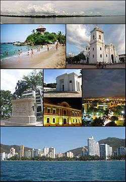 Top:Panorama view of the Cienaga Grande de Santa Marta, from inside the swamp, 2nd left:View of Mirador in Cabo San Juan del Guia, Tayrona Natural Park, 2nd right:Santa Marta Cathedral (La Casa del Farol), 3rd left:Statue of Simon Bolivar in Quinta of Saint Pedro Alejandrino, 3rd upper middle:Colombian National Pantheon in Barrio Mamatoco, 3rd lower middle:Night view of Snta Marta City Hall, 3rd right:Twilight view of Tribute to the Tayrona Ethnicity Square, Bottom:Panoramic view of Acuatico El Rodadero Park and resort area, from De Gaira area | |||
| |||
| عرفیت: America's Pearl (La Perla de America) | |||
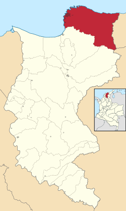 Location in the Department of Magdalena. Municipality (dark gray) City (red) | |||
| ملک |
| ||
| Region | Caribbean Region | ||
| محکمہ | Magdalena | ||
| Foundation | July 29, 1525 | ||
| قائم از | Rodrigo de Bastidas | ||
| وجہ تسمیہ | مرتھا | ||
| حکومت | |||
| • ناظم شہر | Carlos Eduardo Caicedo Omar (Liberal) | ||
| رقبہ | |||
| • شہر | 2,393.65 کلو میٹر2 (924.07 مربع میل) | ||
| • شہری | 55.10 کلو میٹر2 (21.27 مربع میل) | ||
| بلندی | 6 میل (20 فٹ) | ||
| بلند ترین پیمائش[حوالہ درکار] | 5,775 میل (18,947 فٹ) | ||
| آبادی (2010) | |||
| • شہر | 454,860 | ||
| • شہری | 385,122 | ||
| • شہری کثافت | 6,989.5/کلو میٹر2 (18,106.3/مربع میل) | ||
| DANE | |||
| نام آبادی | Samario | ||
| منطقۂ وقت | Colombia Standard Time (UTC-05) | ||
| ٹیلی فون کوڈ | 57 + 5 | ||
| ویب سائٹ | Official website (ہسپانوی زبان میں) | ||

.svg.png)
تفصیلات
سانتا مارتا کا رقبہ 2,393.65 مربع کیلومیٹر ہے اور اس کی مجموعی آبادی 454,860 افراد پر مشتمل ہے اور 6 میٹر سطح سمندر سے بلندی پر واقع ہے۔
مزید دیکھیے
- کولمبیا
- فہرست کولمبیا کے شہر
This article is issued from
Wikipedia.
The text is licensed under Creative
Commons - Attribution - Sharealike.
Additional terms may apply for the media files.