செயிண்ட் ப்யேர் அண்ட் மீகேலோன்
செயிண்ட் ப்யேர் அண்ட் மீகேலோன் (ஆங்கிலம்:Saint Pierre and Miquelon French: Collectivité territoriale de Saint-Pierre-et-Miquelon), கனடாவிற்கருகே வடமேற்கு அட்லாண்டிக் பெருங்கடலில் அமைந்துள்ள பிரான்சின் ஒரு சுய ஆட்சி பிராந்தியமாகும். போர்சிகீசிய மாலுமியொருவரால் 1520 அக்டோபர் 21ல் கண்டுபிடிக்கப்பட்டது[3] . பிரெஞ்சு காலனியத்துவத்தில் உள்ள ஒரே பகுதி இதுதான். ஃபார்ச்சூன் பே, நுழைவு வாயிலிலிருந்து நியூஃபின்லான்ட் தெற்கு கடற்கரை வரை இத்தீவுகள் அமைந்துள்ளது.[4]
செயிண்ட் ப்யேர் அண்ட் மீகேலோன்
|
||||||
|---|---|---|---|---|---|---|
|
||||||
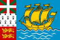
| குறிக்கோள்: A Mare Labor (ஆங்கில மொழியில்) |
||||||
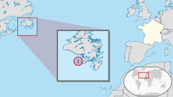 Location of செயிண்ட் ப்யேர் அண்ட் மீகேலோன் |
||||||
| தலைநகரம் | செயிண்ட் ப்யேர் 46°47′N 56°10′W | |||||
| ஆட்சி மொழி(கள்) | பிரெஞ்சு | |||||
| அரசாங்கம் | பிரெஞ்சு காலனி | |||||
| • | பிரெஞ்சு அதிபர் | நிக்கொலா சார்கோசி | ||||
| பரப்பு | ||||||
| • | Total | 242 கிமீ2 (208th) 93 சதுர மைல் |
||||
| மக்கள் தொகை | ||||||
| • | 2011 கணக்கெடுப்பு | 5,888[1] (227th) | ||||
| • | 2009 கணக்கெடுப்பு | 6,345 | ||||
| • | அடர்த்தி | 24.3/km2 (188th) 62.9/sq mi |
||||
| மொ.உ.உ (கொஆச) | 2004 கணக்கெடுப்பு | |||||
| • | மொத்தம் | €161.131 மில்லியன்[2] | ||||
| • | தலைவிகிதம் | €26,073[2] | ||||
| நாணயம் | ஐரோ (€) (EUR) | |||||
| நேர வலயம் | (ஒ.அ.நே−3) | |||||
| • | கோடை (ப.சே) | (ஒ.அ.நே−2) | ||||
| அழைப்புக்குறி | +508 | |||||
| ISO 3166 code | PM | |||||
| இணையக் குறி | .pm | |||||
ஆதாரங்கள்
- Saint Pierre and Miquelon உலகத் தரவுநூலில் இருந்து
- Evaluation du PIB 2004 de Saint-Pierre-et-Miquelon - janvier 2007, page 24
- கூகுள் புத்தகங்களில் Placenames of the world: origins and meanings of the names for 6,600 ... By Adrian Room
- Les iles Saint-Pierre et Miquelon — Notes de la conférence donnée à l'Institut Canadien, devant la Société Géographique de Québec, le 29 avril 1880, par Son Excellence le comte de Premio-Real, consul-général d'Espagne.
This article is issued from
Wikipedia.
The text is licensed under Creative
Commons - Attribution - Sharealike.
Additional terms may apply for the media files.