کاؤنٹی ارماہ
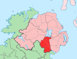
کاؤنٹی ارماہ (انگریزی: County Armagh) برطانیہ کا ایک county of Northern Ireland جو السٹر میں واقع ہے۔[2]
| کاؤنٹی ارماہ Contae Ard Mhacha Coontie Airmagh / Armagh | ||
|---|---|---|
| ||
 | ||
| ملک | United Kingdom | |
| مملکت متحدہ کے ممالک | شمالی آئر لینڈ | |
| Province | السٹر | |
| کاؤنٹی ٹاؤن | آرماہ | |
| رقبہ | ||
| • کل | 1,326 کلو میٹر2 (512 مربع میل) | |
| رقبہ درجہ | 27th | |
| آبادی (2011) | 174,792 | |
| • درجہ | 11th[1] | |
| Contae Ard Mhacha is the Irish name; Coontie Armagh and Coontie Airmagh are السٹر اسکاٹس لہجے spellings. | ||
تفصیلات
کاؤنٹی ارماہ کا رقبہ 1,326 مربع کیلومیٹر ہے اور اس کی مجموعی آبادی 174,792 افراد پر مشتمل ہے۔
مزید دیکھیے
حوالہ جات
- Census figures are no longer released detailing returns for Counties but rather Parliamentary Constituency, Local Government District, Electoral Ward and Output Area. This figure is based on a tally of all persons resident in the wards comprising County Armagh on 29 April 2001, i.e. all electoral wards of the Newry & Armagh Parliamentary Constituency (minus St. Mary's, St. Patrick's and Windsor Hill from County Down) combined with the 17 wards in the Upper Bann Parliamentary Constituency from County Armagh (i.e. Derrytrasna, Birches, Bleary, Drumgask, Taghnevan, Court, Annagh, Brownstown, Ballybay, Ballyoran, Corcrain, Edenderry, Killycomain, Kernan, Drumgor, Mourneview, Church, Knocknashane, Parklane, Woodville, Drumnamoe, and Tavanagh). "Area Profiles"۔ Northern Ireland Neighbourhood Information Service۔ مورخہ 7 جنوری 2019 کو اصل سے آرکائیو شدہ۔ اخذ شدہ بتاریخ 8 اگست 2008۔
- انگریزی ویکیپیڈیا کے مشارکین۔ "County Armagh"۔
This article is issued from
Wikipedia.
The text is licensed under Creative
Commons - Attribution - Sharealike.
Additional terms may apply for the media files.