பெல்பாஸ்ட்
பெல்பாஸ்ட் (ஆங்கிலம்:Belfast), வட அயர்லாந்தின் தலைநகரமும் மிகப்பெரிய நகரமும் ஆகும். மக்கட்தொகை அடிப்படையில் இது ஐக்கிய இராச்சியத்தில் 14வது[16] பெரிய நகரமும் அயர்லாந்து தீவில் டப்லினுக்கு அடுத்தபடியாக இரண்டாவது பெரிய நகரமும் ஆகும். பெல்பாஸ்ட் நகரின் மக்கட்தொகை 267,500[7] ஆகும். 1888இல், பெல்பாஸ்ட் நகர அந்தஸ்து பெற்றது.
| பெல்பாஸ்ட் | |
| சுகாத்து: Bilfawst,[1][2] Bilfaust[3] or Belfast[4][5] | |
| ஐரிஷ்: Béal Feirste[6] | |
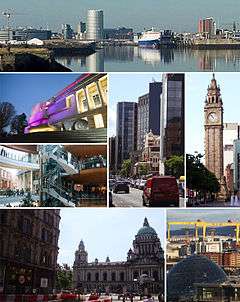 மேல்: பெல்பாஸ்ட் நகரத்தோற்றம், நடு: அல்ஸ்டர் அருங்காட்சியகம், விக்டோரியா சதுக்கம், பெரிய விக்டோரியா சாலை, அல்பேர்ட் கடிகாரம், கீழ்: பெல்பாஸ்ட் நகர மண்டபம், ஹார்லண்டும் வூல்ஃபும் (Harland & Wolff) |
|
.svg.png) |
|
 | |
| பரப்பளவு | 44.4 sq mi (115 km2) |
|---|---|
| மக்கட்தொகை | பெல்பாஸ்ட் நகரம்: 267,500[7] மாநகரம்: 483,418[8] பெருநகரம்: 641,638[9] |
| Irish grid reference | J338740 |
| மாவட்டம் | பெல்பாஸ்ட் நகரம் |
| கவுண்டி | County Antrim County Down |
| நாடு | வட அயர்லாந்து |
| இறையாண்மையுள்ள நாடு | ஐக்கிய இராச்சியம் |
| அஞ்சல் நகரம் | BELFAST |
| அஞ்சல் மாவட்டம் | BT1–BT17, BT29 (part), BT36 (part), BT58 |
| தொலைபேசிக் குறியீடு | 028 |
| காவல்துறை | Northern Ireland |
| தீயணைப்பு | |
| Ambulance | |
| ஐரோப்பிய பாராளுமன்றம் | |
| ஐக்கிய இராச்சிய பாராளுமன்றம் | பெல்பாஸ்ட் வடக்கு பெல்பாஸ்ட் தெற்கு பெல்பாஸ்ட் கிழக்கு பெல்பாஸ்ட் மேற்கு |
| வட அயர்லாந்து சட்டசபை | பெல்பாஸ்ட் வடக்கு பெல்பாஸ்ட் தெற்கு பெல்பாஸ்ட் கிழக்கு பெல்பாஸ்ட் மேற்கு |
| இணையத்தளம் | www.belfastcity.gov.uk |
| இடங்களின் பட்டியல்: ஐக்கிய இராச்சியம் | |
| மக்கள்தொகை வளர்ச்சி | ||
|---|---|---|
| ஆண்டு | ம.தொ. | %± |
| 1821 | 37,277 | — |
| 1831 | 53,287 | +42.9% |
| 1841 | 75,308 | +41.3% |
| 1851 | 97,784 | +29.8% |
| 1861 | 1,19,393 | +22.1% |
| 1871 | 1,74,412 | +46.1% |
| 1881 | 2,08,122 | +19.3% |
| 1891 | 2,55,950 | +23.0% |
| 1901 | 3,49,180 | +36.4% |
| 1911 | 3,86,947 | +10.8% |
| 1926 | 4,15,151 | +7.3% |
| 1937 | 4,38,086 | +5.5% |
| 1951 | 4,43,671 | +1.3% |
| 1961 | 4,15,856 | −6.3% |
| 1966 | 3,98,405 | −4.2% |
| 1971 | 3,62,082 | −9.1% |
| 1981 | 3,14,270 | −13.2% |
| 1991 | 2,79,237 | −11.1% |
| 2001 | 2,77,391 | −0.7% |
| 2006 | 2,67,374 | −3.6% |
| [10][11][12][13][14][15] | ||
மேற்கோள்கள்
- "The Linen Hall Library". The Linen Hall Library. பார்த்த நாள் 2011-04-13.
- 2006 annual report in Ulster-Scots North/South Ministerial Council.
- BBC Ulster-Scots Library – Switherin agen Ullans Speakers Association. Retrieved on the 6 October 2011.
- North-South Ministerial Council: 2010 Annual Report in Ulster Scots
- North-South Ministerial Council: 2009 Annual Report in Ulster Scots
- "Placenames Database of Ireland – Belfast". Logainm.ie. பார்த்த நாள் 2010-08-12.
- "Demography". NISRA. பார்த்த நாள் 2009-05-30.
- The UK's major urban areas Office for National Statistics (Belfast Urban Area defined in footnote 6, page 16 of the pdf)
- http://www.nisra.gov.uk/archive/demography/publications/urban_rural/ur_gaz.pdf
- "Census for post 1821 figures". Cso.ie. பார்த்த நாள் 2010-08-12.
- "Home". Histpop.Org (2007-04-02). பார்த்த நாள் 2010-11-13.
- NISRA. "Northern Ireland Statistics and Research Agency - Census Home Page". Nisranew.nisra.gov.uk. பார்த்த நாள் 2010-08-12.
- Lee, JJ (1981). "On the accuracy of the Pre-famine Irish censuses". in Goldstrom, J. M.; Clarkson, L. A.. Irish Population, Economy, and Society: Essays in Honour of the Late K. H. Connell. Oxford, England: Clarendon Press.
- Joel Mokyr; O Grada, Cormac (November 1984). "New Developments in Irish Population History, 1700–1850". The Economic History Review 37 (4): 473–488. doi:10.1111/j.1468-0289.1984.tb00344.x. http://www3.interscience.wiley.com/journal/120035880/abstract.
- "Belfast City Council. Belfast: A Profile of the City. Demographics". Belfastcity.gov.uk. பார்த்த நாள் 2010-08-12.
- Woodlands - What is the population of Britain's major cities ?
This article is issued from
Wikipedia.
The text is licensed under Creative
Commons - Attribution - Sharealike.
Additional terms may apply for the media files.