தென்முனைப் பெருங்கடல்
தென்முனைப் பெருங்கடல் (Southern Ocean), அல்லது அண்டார்ட்டிக் பெருங்கடல் (Antarctic Ocean)[1] அல்லது the தென் பெருங்கடல் (Austral Ocean)[2][note 3] and the "Southern Icy Ocean".[3][note 4]</ref> என்பது உலகப் பெருங்கடல்களுக்கு மிகவும் தெற்காக அமைந்த நீர்நிலையைக் குறிக்கும். இது புவியின் தென்முனையில் அண்டார்ட்டிகாவை 360 பாகைகளும் சூழ்ந்தபடி 60° தெ அகலாங்குக்கும் தெற்கில் அமைந்துள்ளது.[5] இது ஐந்து முதன்மையான பெருங்கடல்களில் நான்காவது பெருங்கடலாகும்.: மேலும் இது அமைதிக்கடல், அத்லாந்திக் கடல், இந்தியப் பெருங்கடல் ஆகிய மூன்றைவிடச் சிறியதாகும். ஆனால், இது ஆர்க்டிக் பெருங்கடலை விட பெரியதாகும்.[6] இந்தப் பெருங்கடல் வட்டாரத்தில் தான் வடக்குமுகமாகப் பாயும் அண்டார்ட்டிகாவின் தண் நீரோட்டமும் வெத்துவெதுப்பான உள் அண்டார்ட்டிக் நீரோட்டமும் சந்தித்துக் கலக்கின்றன.


.
இப்பெருங்கடல் 20,327,000 சதுர கிலோமீட்டர் (7,848,000 mi²) பரப்பளவுடையது. இதன் ஆழம் மிகப்பெரும்பாலான பரப்பில் பொதுவாக 4,000 மீட்டர் முதல் 5,000 மீட்டர் வரையானதாக உள்ளது (13,000-16,000 அடி). தென்முனைப் பெருங்கடலின் மிக ஆழமான பகுதி 60°00'தெ, 024°மே. என்னும் ஆயங்களில் உள்ளது. இவ்விடத்தில் இப்பெருங்கடல் 7,235 மீட்டர் (23, 735 அடி) ஆழம் உடையது.
அண்டார்ட்டிக்கின் கண்டத் திட்டு வழக்கத்திற்கு மாறாக 800 மீட்டர் (2,600 அடி) ஆழம் உடையதாக உள்ளது. உலகின் பிற கண்டத்திட்டுகளின் சராசரி ஆழம் 133 மீட்டர் (436 அடி) ஆகும். தனது தென்முனைப் பயணத்தின் வழியாக 1770 களில், ஜேம்சு குக் புவிக்கோள தென் அகலாங்குகளில் நீர்நிலை சூழ்ந்திருப்பதை நிறுவினார். அதில் இருந்தே புவிப்பரப்பியலாளர்கள் தென்முனைப் பெருங்கடலின் வடக்கு வரம்பை ஏன், அந்நீர்நிலையின் நிலவலையே ஏற்கவில்லை. மாறாக, இந்த நீர்ப்பகுதியை இவர்கள் அமைதிக்கடல், அத்லாந்திக் கடல், இந்தியப் பெருங்கடல் ஆகியவற்றின் பகுதியாகவே கருதிவந்தனர். இந்தக் கண்ணோட்டமே பன்னாட்டு நீர்வரைவியல் நிறுவனத்தின் கொள்கையாக இதுவரை நிலவுகிறது. ஏனெனில், 2000 ஆம் ஆண்டின் 60 ஆம் அகலாங்குக்குத் தெற்கே உள்ளதாக தென்முனைப் பெருங்கடலை உள்ளடக்கிய வரையறுப்புகள் வேறு காரணங்களால் இன்னமும் ஏற்கப்படாமலேயே உள்ளது. பிறர் பருவந்தோறும் மாறும் அண்டார்ட்டிகா குவிவையே இயற்கையான வரம்பெல்லையாகக் கொள்கின்றனர்.[7]
வரையறுப்புகளும் பயன்பாடும்

பன்னாட்டு நீர்வரைவியல் குழுமம் (இது பன்னாட்டு நீர்வரைவியல் நிறுவனத்தின் முன்னோடியாகும்) 1919 ஜூலை 24 இல் முதல் பன்னாட்டுக் கருத்தரங்கைக் கூட்டியபோது, பன்னாட்டளவில் கடல்கள், பெருங்கடல்களின் எல்லைகளும் பெயர்களும் ஏற்கப்பட்டன. இவற்றை பநீநி 1928 இல் தனது கடல்கள், பெருங்கடல்களின் வரம்புகள் எனும் முதல்பதிப்பில் வெளியிட்டது. முதல் பதிப்பிற்குப் பிறகு, தென்முனைப் பெருங்கடலின் வரம்புகள் தொடர்ந்து நிலையாக தெற்கு நோக்கியே நகர்ந்து வந்துள்ளது; என்றாலும் 1953 க்குப் பிறகு இக்கடல் பநீநியின் அலுவலகப் பதிப்பில் சேர்க்கப்படவில்லை. அப்பணியைக் கள நீர்வரைவியல் அலுவலகங்களைத் தமே எல்லைவரம்புகளை தீர்மானிக்கவிட்டுள்ளது. பநீநி 2000 ஆம் ஆண்டு திருத்தத்தில் இக்கடலை உள்ளடக்கி, இதை 60°தெ அகலாங்குக்குத் தெற்கே உள்ள நீர்நிலையாக வரையறுத்துள்ளது. ஆனால், இது முறையாக இன்னமும் ஏற்கப்படவில்லை. ஏனெனில், யப்பான் கடல் போன்ற பிற கடல் வரையறை சிக்கலால் நிலுவையில் உள்ளது. என்றாலும், 2000 பநீநி (IHO) வரையறுப்பு, 2002ஆம் ஆண்டு வரைவு பதிப்பில் சுற்றுக்கு விடப்பட்டது. இது பநீநியில் சிலராலும் சில வெளி நிறுவனங்களாலும் பயன்படுத்தப்படுகிறது. அவை, அமெரிக்க நடுவண் முகமையம்,[6] மரியம்-வென்சுட்டர்போன்றனவாகும்.[note 5][8] ஆசுத்திரேலிய அதிகார அமைப்புகள் தென்முனைப் பெருங்கடல் அசுத்திரேலியாவுக்கு உடனடித் தெற்கில் அமைவதாக கூறுகின்றன.[9][10] தேசியப் புவிப்பரப்பியல் கழகம் இக்கடலை ஏற்காமல்,[2] மற்ற பெருங்கடல்களுக்குரிய எழுத்துகளில் சுட்டாமல், வேறுபட்ட அச்செழுத்துகளில் குறிக்கிறது; ஆனால், இக்கழகம் தன் நிலப்படத்திலும் இணையதளப் படங்களிலும் அண்டார்ட்டிகா வரை அமைதி, அத்லாந்திக், இந்தியப் பெருங்கடல்கள் நீள்வதாகக் காட்டுகிறது.[11][note 6] தம் உலக நிலப்படத்தில் தென்முனைப் பெருங்கடலைப் பயன்படுத்தும் நிலப்பட வெளியீட்டாளர்கள் ஏமா நிலப்பட நிறுவனம் (Hema Maps), [13] ஜியோநோவா (GeoNova) நிறுவனம் ஆகியவை ஆகும்.[14]
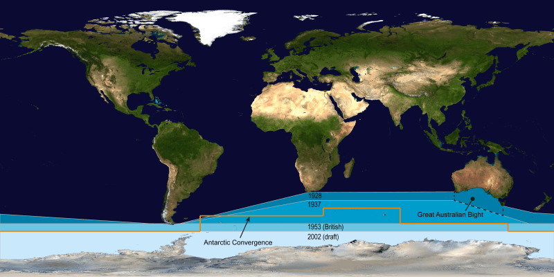 அதன் கடல்கள், பெருங்கடல்களின் வரம்புகள் சார்ந்த 1928 ஆம் ஆண்டின் முதல் பதிப்புக்குப் பிறகு, பன்னாட்டு நீர்வரைவியல் நிறுனத்தின் "தென்முனைப் பெருங்கடல்" சார்ந்த வரையறுப்பில் பின்னதன் வரம்பு தொடர்ந்து நிலையாக தெற்கு நோக்கியே நகர்ந்தது. ஆசுத்திரேலியா இதை தனது தெற்குக் கடற்கரையில் இருந்து தொடங்குவதாகத் தொடர்ந்து கூறிவருகிறது. 1953 வரம்புகள் பெரும்பிரித்தானியாவின் மூன்றாம் பதிப்பின் வரையறுப்பாகும். பிறர், அரசியல் முனைப்பாட்டைச் சாராமல், பருவந்தோறும் மாறும் அண்டார்ட்டிகா குவிவையே இயற்கையான வரம்பெல்லையாகக் கொள்கின்றனர்.[5] |
 தென்முனைப் பெருங்கடல் அண்டார்ட்டிகா நிலப்படம். |
20 ஆம் நூற்றாண்டுக்கு முந்தைய வரையறைகள்
.jpg)
வாசுகோ நூனெசு டி பால்போவா "தென்முனைப் பெருங்கடல் என அமைதிப் பெருங்கடலுக்கு அல்லது தென் அமைதிப் பெருங்கடலுக்குப் பெயரிட்டது தற்போது அருகிவிட்டது. இவர் தான் அமைதிப் பெருங்கடலை வடக்கில் இருந்து அணுகிக் கண்டுபிடித்த முதல் ஐரோப்பியர் ஆவார்.[15] "தென்கடல்கள்" என்பதும் குறைவாகவே வழக்கில் உள்ள அதை நிகர்த்த பெயராகும். 1745 ஆண்டின் பிரித்தானிய நாடாளுமன்றச் சட்டம் அமெரிக்காவின் "மேற்கு, தெற்கு கடல்களுக்குச் செல்ல" "வடமேற்கு கடப்பு" வழியைக் கண்டுபிடிப்பவருக்குப் பரிசு ஒன்றை நிறுவியது".[16]
அறியப்படாத தென்முனை வட்டாரங்களைச் சூழ்ந்தமைந்த நீர்நிலையை தென்முனைப் பெருங்கடல் என பெயரிட்டு எழுதிய ஆசிரியர்கள் பல்வேறு வரம்புகளை குறிப்பிட்டனர். ஜேம்சு குக் அவர்களது இரண்டாம் பயண விவரிப்பு அதன் வரம்பில் நியூ கலெடோனியா அமைவதாக புலப்படுத்துகிறது.[17] பீகாக்கின் 1795 ஆம் ஆண்டு புவிப்பரப்பியல் அகரமுதலி இக்கடல் "அமெரிக்காவுக்கும் ஆப்பிரிக்காவுக்கும் தெற்கில்" அமைவதாக கூறுகிறது;[18] ஜான் பெய்னே 1796 இல் இக்கடலின் வடக்கு வரம்பாக 40 பாகை அகலாங்கைப் பயன்படுத்தினார்;[19] 1827 ஆம் ஆண்டு எடின்பர்கு அரசிதழ் 50 பாகை அகலாங்கை வக்கு வரம்பாகப் பயன் படுத்தியது.[20]> குடும்ப இதழ் (Family Magazine) 1835 இல் "பெருந்தென் பெருங்கடலை" "தென்பெருங்கடல்" எனவும் "அண்டார்ட்டிக் [சிக்] பெருங்கடல்" எனவும் அண்ட்டர்ட்டிக் வட்ட்த்தைச் சூழ்ந்தமைந்த கடலை இரண்டாகப் பிரித்தது. இதன் வடக்கு வரம்பாக, கொம்புமுனையையும் நன்னம்பிக்கை முனையையும் இணைக்கும் கோட்டையும் வான் தியெமன் நிலத்தையும் நியூசிலாந்தின் தெற்குப் பகுதியையும் இணைக்கும்கோட்டையும் குறிப்பிட்ட்து.[21]
குறிப்புகள்
- Also a translation of its former French name (Grand Océan Austral) in reference to its position below the Pacific, the "Grand Océan".
- Used by Dr Hooker in his accounts of his Antarctic voyages.<ref>Hooker, Joseph Dalton (1844), Flora Antarctica: The Botany of the Antarctic Voyage, London: Reeve.
- Historic names include the "South Sea",[3] the "Great Southern Ocean",[4][note 1] the "South Polar Ocean" or "South-Polar Ocean",[note 2] Also a translation of the ocean's Japanese name Nankyoku Kai (南極海).
- Also a translation of the ocean's Chinese name Nánbīng Yáng (南冰洋).
- A subsidiary of Encyclopædia Britannica, Inc.
- In violation of their Style Guide,[2] however, some of National Geographic's online news blogs do use the term.[12]
சான்றுகள்
- EB (1878).
- NGS (2014).
- Sherwood, Mary Martha (1823), An Introduction to Geography, Intended for Little Children, 3rd ed., Wellington: F. Houlston & Son, p. 10.
- EB (1911).
- "Geography - Southern Ocean". CIA Factbook. பார்த்த நாள் 16 July 2012. "... the Southern Ocean has the unique distinction of being a large circumpolar body of water totally encircling the continent of Antarctica; this ring of water lies between 60 degrees south latitude and the coast of Antarctica and encompasses 360 degrees of longitude."
- "Introduction - Southern Ocean". CIA Factbook. பார்த்த நாள் 16 July 2012. "...As such, the Southern Ocean is now the fourth largest of the world's five oceans (after the Pacific Ocean, Atlantic Ocean, and Indian Ocean, but larger than the Arctic Ocean)."
- Pyne, Stephen J.; The Ice: A Journey to Antarctica. University of Washington Press, 1986. (A study of Antarctica's exploration, earth-sciences, icescape, esthetics, literature, and geopolitics)
- "Southern Ocean". Merriam-Webster. பார்த்த நாள் 18 January 2014.
- Darby, Andrew (22 December 2003). "Canberra all at sea over position of Southern Ocean". The Age. http://www.theage.com.au/articles/2003/12/21/1071941610556.html. பார்த்த நாள்: 13 January 2013.
- "Indian Ocean". Encyclopædia Britannica. பார்த்த நாள் 13 January 2013.
- "Maps Home". National Geographic Society. பார்த்த நாள் 31 March 2014.
- "Southern Ocean - News Watch". National Geographic. பார்த்த நாள் 26 April 2013.
- "Upside Down World Map". Hema Maps. பார்த்த நாள் 22 July 2014.
- "Classic World Wall Map". GeoNova. பார்த்த நாள் 22 July 2014.
- "Balboa, or Pan-Pacific Day". The Mid-Pacific Magazine (Pan-Pacific Union) 20 (10): 16. "He named it the Southern Ocean, but in 1520 Magellan sailed into the Southern Ocean and named it Pacific".
- Tomlins, Sir Thomas Edlyne; Raithby, John (1811). "18 George II c.17". The statutes at large, of England and of Great-Britain: from Magna Carta to the union of the kingdoms of Great Britain and Ireland. Printed by G. Eyre and A. Strahan. பக். 153. https://books.google.com/books?id=n49KAAAAYAAJ&pg=PA153. பார்த்த நாள்: 1 November 2015.
- Cook, James (1821). "March 1775". Three Voyages of Captain James Cook Round the World. Longman. பக். 244. https://books.google.com/books?id=irYBAAAAYAAJ&pg=PA244. பார்த்த நாள்: 1 November 2015. "These voyages of the French, though undertaken by private adventurers, have contributed something towards exploring the Southern Ocean. That of Captain Surville, clears up a mistake, which I was led into, in imagining the shoals off the west end of New Caledonia to extend to the west, as far as New Holland."
- A Compendious Geographical Dictionary, Containing, a Concise Description of the Most Remarkable Places, Ancient and Modern, in Europe, Asia, Africa, & America, ... (2nd ). London: W. Peacock. 1795. பக். 29. https://books.google.com/books?id=8a9bAAAAQAAJ&pg=PA29.
- Payne, John (1796). Geographical extracts, forming a general view of earth and nature... illustrated with maps. London: G. G. and J. Robinson. பக். 80. https://books.google.com/books?id=63tZAAAAYAAJ&pg=PA80. பார்த்த நாள்: 1 November 2015.
- The Edinburgh Gazetteer: Or, Geographical Dictionary: Containing a Description of the Various Countries, Kingdoms, States, Cities, Towns, Mountains, &c. of the World; an Account of the Government, Customs, and Religion of the Inhabitants; the Boundaries and Natural Productions of Each Country, &c. &c. Forming a Complete Body of Geography, Physical, Political, Statistical, and Commercial with Addenda, Containing the Present State of the New Governments in South America.... 1. London: Longman, Rees, Orme, Brown, and Green. 1827. பக். LIX. https://books.google.com/books?id=YhIyAQAAMAAJ&pg=PR59.
- "Physical Geography". Family Magazine: Or Monthly Abstract of General Knowledge (New York: Redfield & Lindsay) 3 (1): 16. June 1835. https://books.google.com/books?id=sGpMAAAAMAAJ&pg=PA16.
மேற்கோள்கள்

- Brindley, David, ed. (2014), "Antarctic Ocean, Austral Ocean, Southern Ocean", Style Manual, Washington: National Geographic Society, retrieved 31 July 2015.
மேலும் படிக்க
- Gille, Sarah T. 2002. "Warming of the Southern Ocean since the 1950s": abstract, article. Science: vol. 295 (no. 5558), pp. 1275–1277.
- Descriptive Regional Oceanography, P. Tchernia, Pergamon Press, 1980.
- Matthias Tomczak and J. Stuart Godfrey. 2003. Regional Oceanography: an Introduction. (see the site)
வெளி இணைப்புகள்
- Oceanography Image of the Day, from the Woods Hole Oceanographic Institution
- The CIA World Factbook's entry on the Southern Ocean
- The Fifth Ocean from Geography.About.com
- The International Bathymetric Chart of the Southern Ocean (IBCSO) National Geophysical Data Center
- U.S. National Oceanic and Atmospheric Administration (NOAA): Limits of Oceans and Seas (2nd Edition), extant 1937 to 1953, with limits of Southern Ocean.
- NOAA In-situ Ocean Data Viewer Plot and download ocean observations
- NOAA FAQ about the number of oceans
- Commission for the Conservation of Antarctic Marine Living Resources
| பெருங்கடல்கள் |
|---|
| அத்திலாந்திக்குப் பெருங்கடல் • ஆர்க்டிக் பெருங்கடல் • இந்தியப் பெருங்கடல் • தென்முனைப் பெருங்கடல் • அமைதிப் பெருங்கடல் |