


Step 1.2 Gathering Health Concerns and Other Information
 ShareCompartir
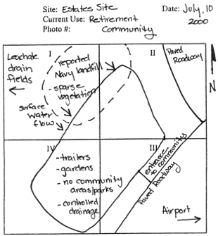
Quadrant Mapping
Quadrant mapping is one method for gathering and organizing data during a site visit. By using this or other methods consistently, health assessors will become efficient and thorough in gathering information that is needed about a site.
To view the steps for using a quadrant mapping system, click on each of the numbered steps below. To view a completed quadrant mapping sheet, click on the Quadrant Mapping Example link.
Step 1
Divide the site into four quarters
Step 2
For each quadrant, sketch important features(for example, source areas, streams, and wells).
Step 3
For each quadrant, complete table noting site characteristics that can impact exposures ( for example, site access and vegetative cover).
Step 4
After the site visit, review information to help identify exposure pathways.
Quadrant Mapping Example
- Page last reviewed: May 31, 2016
- Page last updated: May 31, 2016
- Content source: