


Geospatial Research, Analysis and Services Program (GRASP)
 ShareCompartir
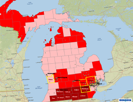
- Provides leadership and expertise in applying the concepts, methods, and tools of geospatial information science to public health research and practice;
- Collaborates with scientists and researchers at CDC/ATSDR and our public health partners to address environmental health and emergency preparedness and response issues; and
- Embraces, leverages, and promotes geospatial technology.
- Page last reviewed: September 23, 2015
- Page last updated: April 12, 2013
- Content source: Agency for Toxic Substances and Disease Registry