PUBLIC HEALTH ASSESSMENTSaipan Capacitors
(a/k/a Tanapag Village (Saipan))
Tanapag Village, Saipan, Commonwealth of the Northern Marianas Island
EPA Facility ID: MPD982524506
August 31, 2004
Nature and Extent of Environmental PCB Contamination
An important part of understanding whether or not PCBs are harming people living in Tanapag Village and addressing community concerns is understanding where PCBs have been found and how much is present in the environment. The EPA, CNMI DEQ and the ACOE investigated the extent of PCB contamination in Tanapag Village (see section 3.0 Background). This section describes the environmental sampling in the village and discusses the location and concentration of detected PCB contamination.What were the results of the investigations conducted to understand PCB contamination at Tanapag Village?
Parts per million, or ppm, is a way to describe the concentration of a contaminant in the environment. One ppm of PCB in soil means one part contaminant to million parts soil. One ppm is analogous to one inch in 16 miles.
Sometimes, ppm is expressed as mg/Kg, or milligram PCB per kilogram soil. A kilogram is approximately 2.2 pounds. One million milligrams equals one kilogram. During investigations, surface soil, biota (animals and plants), surface water and sediment, and groundwater samples were collected and analyzed for PCBs. In evaluating soil contamination and potential exposures, Tanapag Village can be divided into five geographic areas referred to as: Cemetery 1, Community Church, Tanapag Beach Area, Cemetery 2, and Other Tanapag Village Locations. Extensive investigations and remediation have also been conducted at the DPW LBY, however, this area is capped and restricted from public access. As such, this area is not considered a concern for contact by local residents. Biota, surface water, sediment and groundwater samples were evaluated for the village as a whole because exposures are not dependent on location and for some environmental media only a few samples were collected.
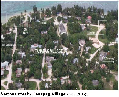
Figures 3 and 5 show village sampling locations and contaminated areas that were the focus of remedial investigations.
Surface Soil Investigation Results
Cemetery 1/Tanapag Elementary School/Residences
The Cemetery 1 area is in the middle of Tanapag Village. A cemetery, the Tanapag Elementary School, surrounding homes, a recycling center, and basketball court west of the school are included in this geographic area. Within the Cemetery 1 area, surface soil samples were collected from 15 individual sites, several residential/private properties, the basketball court, and the Tanapag Elementary School. Table 1 includes a description of each of these areas.
In 1989, the CNMI DEQ and the ACOE collected soil samples in conjunction with the removal of the capacitors from the Cemetery 1 area. Results from the CNMI DEQ sampling event are unavailable. The ACOE collected surface soil samples from throughout Cemetery 1 and found a maximum PCB concentration of 36,000 parts per million (ppm), which is lower than concentrations detected in later investigations (Woodward-Clyde 1990). In 1992, the ACOE conducted remediation and verification sampling at a number of sites in the Cemetery 1 area (Woodward-Clyde 1995). Additional surface soil samples were collected in 1997 and 2000 as part of investigation and remediation activities conducted by the ACOE and EPA, respectively.
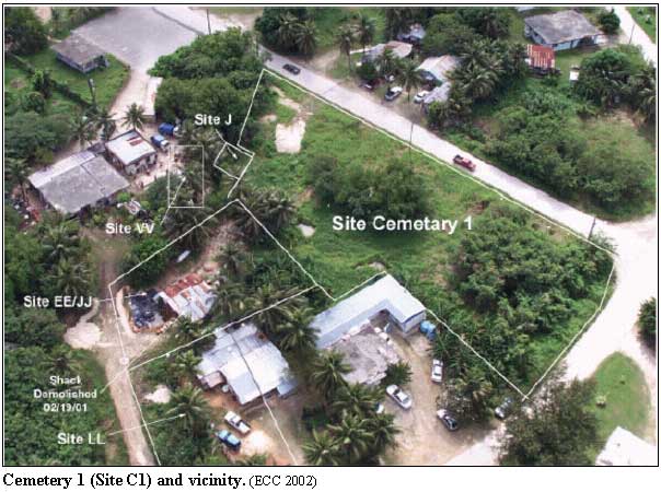
The maximum detected PCB concentration (295,206 ppm) was found at Site Q, located within Cemetery 1 (ECC 1999). In addition to PCBs, EPA collected two composite soil samples from Site LL and analyzed these samples for dioxins and furans. Neither dioxins or furans were detected (ECC 1999; EPA 2001). Table 1 summarizes the range of PCB concentrations found at the individual sites sampled within the Cemetery 1 area and the amount of soil removed based on sampling results.
Community Church/Head Start Building/Ballfields
The Community Church area, located in the northwestern part of Tanapag Village adjacent to the Cemetery 1 area, includes the community church, the former Head Start building, former baseball fields adjacent to the Head Start building, and several private homes. Over the investigation history of this area, surface soil samples were collected from four individual sites, several residential/private properties, a baseball field, and north of the Head Start building. Table 2 includes a description of each of these areas.
Investigations in the Community Church area began in September 1989, when the ACOE collected five soil samples along the northwest side of the Tanapag Head Start building, which likely corresponds to Site A of the 1997 investigation, and one sample along a roadway north of this building, which likely corresponds to Site E of the 1992 and 1997 investigations (Woodward-Clyde 1990; Woodward-Clyde 1995; EPA 2001). In 1992, the ACOE conducted additional sampling and began remediation efforts at the Head Start building. Excavations conducted as part of the remediation effort occurred in four locations-Sites A, B, C, and E (Woodward-Clyde 1995). The ACOE and EPA conducted additional sampling and remediation in 1997 and 2000, respectively. Samples collected from the residential/private property contained the maximum detected PCB concentration for this area (8,000 ppm) (ECC 1999; EPA 2001). Table 2 summarizes the range of PCB concentrations found at the individual sites sampled within the Community Church area and the amount of soil removed based on sampling results.
Tanapag Beach/Orange Pavilion/Community Center
Tanapag Beach, Tanapag Beach Park, the Community Center, the Orange Pavilion, and residences in the vicinity of the beach are included in this area. Surface soil samples have been collected from six individual sites, south of the Orange Pavilion, and south of the community center during investigations of the Tanapag Beach area. Table 3 includes a description of each of these areas.
The ACOE collected soil samples from Tanapag Beach, a nearby home, and proximate to the Tanapag Meeting Hall in September 1989. No PCBs were detected in the sample collected at the home. Samples collected east of the Meeting Hall likely corresponds to Site Z of the 1997 investigation and the sample collected southeast of the Meeting Hall likely corresponds with Site AA of the 1997 investigation (Woodward-Clyde 1990; EPA 2001). The ACOE collected samples at three sites and conducted remediation at two sites in the Tanapag Beach area in 1992 (Woodward-Clyde 1995). The ACOE and EPA conducted additional sampling in 1997 and 2000, respectively. The maximum detected PCB concentration was found during the 1989 sampling of Site Z (31,600 ppm). The ACOE also sampled Site Z for dioxins and furans in 1989 and 1999; dioxins and furans were found at low levels (ECC 1999; EPA 2001). Table 3 summarizes the range of PCB concentrations found at the individual sites sampled within the Tanapag Beach area and the amount of soil removed based on sampling results.
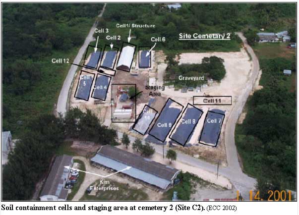
Cemetery 2
The Cemetery 2 area, 0.75 miles south of the main village, includes the cemetery itself (including Kim Enterprises), residential/private property, and the Handsome Garment Factory. Cemetery 2 covers approximately 2.3 acres and was used by the ACOE as a thermal treatment area to address PCB-contaminated soil found within and near Cemetery 2 (ECC 2002). During the 1997 ACOE and 2000 EPA investigations, surface soil samples were collected from within Cemetery 2, along the outer road, residential/private property, and the Handsome Garment Factory (ECC 1999; EPA 2001). Table 4 includes a description of each of these areas.
The maximum PCB concentrations were found within Cemetery 2 (25,929 ppm) (ECC 1999; EPA 2001). Table 4 summarizes the range of PCB concentrations found at the individual sites sampled within the Cemetery 2 area and the amount of soil removed based on sampling results.
Other Tanapag Village Locations
In addition to investigations conducted at the four distinct geographic areas (Cemetery 1, Community Church, Tanapag Beach, and Cemetery 2 areas), the ACOE and EPA collected samples from various locations throughout Tanapag Village during investigations. Areas sampled include Site NN, 7 miscellaneous areas in Tanapag Village, 11 residential/private properties, and the St. Lourdes Store. Table 5 includes a description of each of these areas.
Sampling and remediation in the Other Tanapag Village Locations occurred in 1992, 1997, 2000, and 2001. A sample from Site NN contained the maximum detected PCB concentration (850 ppm) found in the remaining areas of Tanapag Village (Woodward-Clyde 1995; ECC 1999; EPA 2001). Table 5 summarizes the range of PCB concentrations found at the individual sites sampled within other Tanapag Village locations and the amount of soil removed based on sampling results.
Biota Investigation Results
As part of the 2000 investigations, EPA and CNMI DEQ collected samples of biota (plants and animals) from various areas in and around Tanapag Village. Biota sampled included fish, clams, land crabs, chicken eggs, taro and yams (EPA 2001). In addition, EPA and CNMI DEQ collected 92 land crabs from four harvest areas near Tanapag and a background (reference) location near Smiling Cove (Figure 7). Analysis of the crab revealed PCB ranging from 0.0007 to 0.9600 milligrams per kilogram (mg/kg) with an average of 0.0242 mg/kg. A few of the crab were tested for metals. Three metals (iron, aluminum, and manganese) were detected at low levels. Further details are in appendix 14.7.
PCBs were found in low concentrations in taro (0.000084 ppm), and yams (0.000229 ppm) at levels below concern for health harm. PCBs were detected below the levels in many domestic foods (see Table 5 in appendix 14.7). Table 6 summarizes the biota sampling program and results.
Surface water and Sediment Investigation Results
During the May 2000 investigation, EPA collected four surface water and six sediment samples. Additionally, two surface water samples were taken from the Homestead Area Stream immediately downstream of a sediment sample containing PCBs and one sample from the mouth of the Homestead Area Stream as it enters Tanapag Lagoon. A background sample was collected from a stream south of the village. EPA collected one sediment sample from the Northern Stream, four sediment samples from the Homestead Area Stream, and one sediment sample from the Tanapag Lagoon. No PCBs were detected in any of the four surface water samples. PCBs were found in the sediment sample from the Northern Stream (0.005 ppm) and one sediment sample from the Homestead Area Stream (0.32 ppm) (EPA 2001).
Groundwater Investigation Results
In 1988, the ACOE installed three groundwater monitoring wells in the Tanapag Homestead area, located in the southern portion of Tanapag Village, to monitor the potential effect of above ground storage tanks from World War II. EPA sampled these wells during the 2000 investigations. An additional 18 water supply wells operated by the Commonwealth Utility Corporation (CUC) and the Handsome Garment Factory were sampled as part of an island-wide investigation.
Samples from the monitoring wells were analyzed for PCBs, semivolatile organic compounds (SVOCs), and metals. Samples from the supply wells were analyzed for PCBs. No PCBs were found in either the monitoring wells or supply wells. Two SVOCs were found, but these chemicals (bis(2-ethylhexyl)phthalate and diethylphthalate) are common laboratory contaminants and are not likely present in the groundwater. Metals (arsenic, barium, cadmium, chromium, copper, lead, mercury, nickel, silver, and zinc) were present below drinking water standards. Only thallium exceeded its EPA drinking water standard (2 parts per billion [ppb]). Detected thallium concentrations ranged from 2.3 to 3.6 ppb. The wide geographical distribution of detected concentrations combined with the narrow range of detected concentrations indicates a natural source of thallium, such as minerals and rocks in the soil. Regardless, the groundwater underlying Tanapag Village is saline (salty); so people use bottled water or rainwater for drinking water (EPA 2001). As such, exposure to thallium at levels above the EPA drinking water standard is not expected.
In addition to the investigations of PCBs, what are the results of investigations at the Former Tanapag Fuel Farm and the Former Tanapag Military Disposal Site?
EPA conducted investigations at a former fuel farm and former military disposal site in May 2000. The former fuel farm, located south of Tanapag Village and east of Cemetery 2, consists of 42 above ground fuel storage tanks and associated piping built and used in the 1940s (EPA 2002a). The former military disposal site is located in a ravine approximately 0.75 miles from the center of Tanapag Village. Debris was likely disposed of several decades ago and consists of solid waste, such as battery parts, flashlight casings, canteens, metal trays, bed springs, 55-gallon drum pieces, helmets, and other various rusted metal debris. Upstream of this area, a large area of an asphalt-like material was found within the streambed at the bottom of the ravine (EPA 2002b).
EPA gathered five surface soil samples from the former fuel farm and five surface soil samples from the former military disposal area. EPA also collected groundwater from three monitoring wells near the former fuel farm. The results of the groundwater monitoring are summarized in this report under the discussion of groundwater sampling results conducted to understand PCB contamination. Surface soil samples from these two sites were analyzed for PCBs, SVOCs, and metals. PCBs were found in three of five samples from the former fuel farm (0.002 to 0.2 ppm) and three of the five samples from the former military disposal area (0.003 to 0.044 ppm). No SVOCs were detected in the former fuel farm samples or former military disposal area samples. Metals were found in all samples collected and analyzed, however, metals are a natural component of soil. Detected metal concentrations were below EPA remediation goals for residential soils, except for arsenic (140 ppm), chromium (650 ppm), and iron (470,000 ppm) concentrations found in one sample from the former military disposal area. The EPA remediation goals for these metals are 22 ppm for arsenic, 450 ppm for chromium, and 100,000 for iron. The sample containing the elevated levels of arsenic, chromium, and iron was collected from the center of the disposal area (EPA 2002a, 2002b).
A critical part of determining whether or not PCB contamination in the village could harm residents is understanding how people may contact the contamination. A person that comes into contact with PCB is said to be exposed.
What is meant by exposure?
ATSDR's analyses are exposure, or contact, driven. Chemical contaminants disposed or released into the environment have the potential to cause adverse health effects. However, a release does not always result in exposure. People can only be exposed to a contaminant if they come in contact with that contaminant. Exposure may occur by breathing, eating, or drinking a substance containing the contaminant or by skin contact with a substance containing the contaminant.
Situations where no exposures are occurring, because either PCBs are inaccessible or PCBs have not been found, are referred to as incomplete pathways. Examples of incomplete pathways at Tanapag Village include subsurface soil containing PCBs that is inaccessible to villagers (e.g., PCBs in soil contained under the DPW LBY impermable cap to prevent migration) or groundwater which is accessible to villagers, but contains no PCBs.
How does ATSDR determine which exposure situations to evaluate?
Remember, in order for adverse health effects to occur from site-specific contaminants:
|
If someone is exposed, will they get sick?
Exposure does not always result in harmful health effects. The type and severity of health effects that occur in an individual from contact with a contaminant depend on the exposure concentration (how much), the frequency and/or duration of exposure (how long), the route or pathway of exposure (breathing, eating, drinking, or skin contact), and the multiplicity of exposure (combination of contaminants). Once exposure occurs, characteristics such as age, sex, nutritional status, genetics, lifestyle, and health status of the exposed individual influence how the individual absorbs, distributes, metabolizes, and excretes the contaminant. Together, these factors and characteristics determine the health effects that may occur as a result of exposure to a contaminant in the environment.
To account for the uncertainty inherent in estimating exposures and to be protective of public health, ATSDR scientists typically define a range of exposure from average to worst-case exposure level estimates as the basis for determining whether adverse health effects are possible. Because of conservative assumptions about how people may be exposed, estimated exposure levels usually are much higher than the levels that people are really exposed to. If the exposure levels indicate that adverse health effects are possible, then a more detailed review of exposure combined with scientific information from the toxicological and epidemiologic literature about the health effects from exposure to hazardous substances is performed.
Who was/is exposed to PCBs in Tanapag Village?
As outlined in the Nature and Extent section of this report, PCB contamination was found in surface soil, biota, and sediment located throughout Tanapag Village. No PCBs were found in groundwater. As a result, ATSDR conservatively assumed that any resident of Tanapag Village could be exposed to PCBs. The extent of this exposure is influenced by an individual's activities, such as playing in the former baseball fields, eating crab caught near Tanapag Lagoon, or visiting the village cemeteries. The duration (how long) and frequency (how often) of these activities also influence the extent of exposures.
Table 7 summarizes the possible exposure situations considered for Tanapag Village.
When did exposures begin? What is the exposure duration?
The capacitors, which were the source of PCBs, were given to Tanapag Village in 1972 (Prasad 1999). The PCBs contained in the capacitors were not released to Tanapag Village and available for exposures until leaks and cracks formed in the capacitors. When the leaks and cracks began, however, is unknown. As such, ATSDR assumed that the leaks and cracks were present in the capacitors when they were given to the village. Although time is needed for PCBs to move from the capacitors throughout Tanapag Village, ATSDR conservatively assumed that exposures to PCBs in any media (surface soil, biota, and sediment) could have begun in 1972, representing an exposure duration of 30 years.
How often were/are people exposed?
The frequency of exposure depends on how often different activities occur that would bring someone into contact with contamination. For example, exposures to PCBs in biota depend on how often a person eats crab caught around Tanapag Lagoon. Climate constraints can play a role in determining how often some activities occur, such as children playing outside. Typical of the tropical marine climate in Saipan, days are hot and humid with a rainy season occurring from July to October. As such, outdoor activities and potentially related exposures could occur year round.
How could people be exposed to PCBs in surface soil?
Villagers could be exposed to PCBs in soil if they conducted activities in areas where surface soil contamination has been found. Sampling detected PCBs in surface soil in a number of locations found throughout Tanapag Village. As described in the Nature and Extent section of this report, surface soil contamination has been characterized in five geographic areas (Cemetery 1, Community Church, Tanapag Beach, Cemetery 2, and Other Tanapag Village Locations). The types of exposures that can occur depend on the activities conducted in each of these areas. Regardless of the location or activities, exposures occur when children or adults accidentally ingest soil (e.g., eat without washing contaminated soil from one's hands), touch soil (e.g., walk barefoot across contaminated soil), or breath dust generated from the contaminated soil. Many areas are overgrown with grasses and other vegetation that would impede contact with underlying soil contamination, reducing the potential for exposure.
The Cemetery 1 area is in the middle of Tanapag Village and includes a cemetery, the Tanapag Elementary school, residential/private property, and a basketball court. Children and adults may come into contact with PCBs in surface soil during activities at any of these locations (e.g., playing games, gardening, using outdoor bathrooms). At the cemetery, exposures to adults and children may occur when they visit grave sites. Maintenance activities, such as digging graves or landscaping, may result in adult exposures at these locations.
The Community Church area in the northwest of Tanapag Village includes sites near a community church, the former Head Start building, baseball fields, and residential and private property. The former Head Start building, which was closed in November 1988, and approximately ten homes are within 200 feet of the identified areas of PCB-contaminated soil. Similar to the Cemetery 1 area, children and adults may have contacted surface soil contamination during recreational activities, such as playing games during the Head Start program, playing baseball, and gardening. Children and adults may also contact PCBs during church activities if these activities occur in areas of soil contamination. Adults could also be exposed during maintenance activities, such as landscaping tasks.
Sites near Tanapag Beach, including the Community Center, Orange Pavilion, and nearby residences, comprise the Tanapag Beach area. As with the other areas, recreational activities, such as playing along the beach, holding bar-b-ques, or picnicking at the beach, can lead to exposures to adults and children. Fishermen that harbor boats at Tanapag Beach Park may also be exposed to PCBs in soil at the Tanapag Beach area when they repair their nets in this area (Ogden 1999).
The Cemetery 2 area includes a cemetery, nearby residential/private property, and the Handsome Garment Factory. Similar to the Cemetery 1 area, exposures to adults and children may occur when they visit grave sites or during recreational activities if children or adults play at the cemetery. Maintenance activities, such as digging graves or landscaping, may result in adult exposures at the cemetery, residences, or the garment factory.
The Other Tanapag Village Locations encompass sites throughout Tanapag Village, including Site NN, residential/private property, and a store. Several residents unknowingly obtained soil from areas of PCB contamination for use in planters at their homes (Ogden 1999) Children and adults playing or engaging in recreational activities (e.g., playing at Site NN or gardening at their homes) at any of these areas may come into contact with to PCBs. Maintenance activities, such as landscaping, may result in adult exposures at these locations.
How could people be exposed to PCBs in locally harvested foods?
Exposure to PCBs could occur if villagers eat local food items that have been in contact with PCBs. Villagers use Tanapag Lagoon for recreational and commercial fishing and consume the fish and clams that they catch. Sampling, however, found no PCBs in either fish or clams. On land, villagers raise chicken, capture land crabs, and grow fruits and vegetables in areas that may contain PCBs in the surface soil. No PCBs have been found in chicken eggs, however, PCBs have been detected in some land crabs. Taro and yam samples also had PCBs at very low levels (EPA 2001).
More details about land crab contamination and ATSDR's evaluation of the public health impact can be found in appendix 14.7
How could people be exposed to PCBs in surface water and sediment?
PCBs in surface soil can be carried to streams and Tanapag Lagoon in rainwater runoff. The ground in Tanapag Village is highly permeable, however, so little rainwater runoff forms to carry PCBs to surface water bodies. Three streams run through Tanapag Village: Homestead stream (located south of the village), Achugao stream (located north of the village), and Agatan stream (located south of the village). Each of these streams is intermittent-water only flows in the stream for part of the year-and flows into Tanapag Lagoon. Tanapag Lagoon is an approximately 20 square mile area of shallow water separated from the Philippine Sea by a barrier reef located 2 miles offshore of Tanapag Harbor (ACOE 2001b; ATSDR 2001).
Sampling found no PCBs in surface water. PCBs were detected in sediment. Villagers that use the streams and Tanapag Lagoon for recreational activities, such as swimming, wading, or fishing, may contact PCBs in sediments. Incidental ingestion would occur when people accidentally or unintentionally ate sediments. For example, eating a meal without washing sediment that may be on ones hands or face. Dermal (skin) contact would occur when people touch sediments containing PCBs during recreational activities, for example, wading barefoot through contaminated sediments.
How could people be exposed to PCBs in groundwater?
No PCBs were found in groundwater samples collected from monitoring wells in Tanapag Village and supply wells throughout Saipan. No exposures to PCBs in groundwater, therefore, are occurring.
ATSDR gathered information about how villagers use groundwater underlying Tanapag Village. Two springs that serve as water supplies for Saipan are found within 1 mile of Tanapag Village (Achugao Springs is 0.8 miles northeast and Tanapag Springs is 0.5 miles southeast). These springs are located up gradient of the village and are used for washing, bathing and in some instances, cooking. In Tanapag Village, people use bottled water or rainwater for drinking water because the groundwater is too saline (salty) to drink (EPA 2001). CUC operates approximately 109 production wells on Saipan and supplies water to approximately 37,650 people. The nearest CUC production well to Tanapag Village is 2.5 miles to the southwest. Approximately 125 private wells are also operated throughout the island of Saipan. These private wells are generally used for industrial and commercial purposes (EPA 2001). The nearest private well to Tanapag Village is within 1 mile to the south (Weston 2001).
