কঙ্গো নদী
কঙ্গো নদী আফ্রিকা মহাদেশেের দ্বিতীয় দীর্ঘতম নদী এবং জলপ্রবাহের দিক থেকে পৃথিবীর দ্বিতীয় সর্বাধিক জলপ্রবাহিত হওয়া নদী। গভীরতার দিক থেকে এটি পৃথিবীর গভীরতম নদী যার গভীরতা ২২০ মি (৭২০ ফু)।[1]
| কঙ্গো নদী | |
|---|---|
 | |
| অন্য নাম | জায়ারে নদী |
| অববাহিকার বৈশিষ্ট্য | |
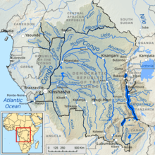
| মূল উৎস | লুয়ালাবা নদী বয়োমা জলপ্রপাত |
| মোহনা | আটলান্টিক মহাসাগর |
| অববাহিকার আকার | ৪০,১৪,৫০০ কিমি২ (১৫,৫০,০০০ মা২) |
| প্রাকৃতিক বৈশিষ্ট্য | |
| দৈর্ঘ্য | ৪,৭০০ কিমি (২,৯০০ মা) 2 |
| নিষ্কাশন |
|
নামকরণ
কঙ্গো নদীর নামটি এসেছে এর দক্ষিণ প্রান্তের একসময়ের কঙ্গো সাম্রাজ্য হতে। আর, এই সাম্রাজ্যের নামকরণকরা হযেছিলো আদিবাসী বান্টুদের থেকে, যাদেরকে ১৭দশ শতকে ডাকা হতো এসিকঙ্গো নামে।[2]
তথ্যসূত্র
- Oberg, Kevin (জুলাই ২০০৮)। "Discharge and Other Hydraulic Measurements for Characterizing the Hydraulics of Lower Congo River, July 2008" (PDF)। U.S. Geological Survey।
- Anderson, David (২০০০)। Africa's Urban Past। পৃষ্ঠা 79। আইএসবিএন 9780852557617।
বহিঃসংযোগ
- The Royal Geography Society's Hidden Journeys project:
- The River Congo Basin ** Audio slideshow: The River Congo: Following in Explorer Sir Henry Morton Stanley's Footsteps – Tim Butcher recounts his trip through the Congo on the route of 19th-century explorer Sir Henry Morgan Stanley.
- Bibliography on Water Resources and International Law Peace Palace Library
- Map of the Congo River basin at Water Resources eAtlas
- The Congo Project, American Museum of Natural History
This article is issued from
Wikipedia.
The text is licensed under Creative
Commons - Attribution - Sharealike.
Additional terms may apply for the media files.