অ্যাকনকাগুয়া পর্বত
অ্যাকোনকাগুয়া (ইংরেজি: Aconcagua, স্পেনীয় উচ্চারণ: [akoŋˈkaɣwa]) আমেরিকা অঞ্চলের সর্বোচ্চ পর্বতশৃঙ্গ। এর উচ্চতা ৬,৯৬০.৮ মিটার বা ২২,৭৮৩৭ ফিট[1] এবং এশিয়ার বাইরে এটিই পৃথিবীর সর্বোচ্চ পর্বত। অ্যাকনকাগুয়া পশ্চিমগোলার্ধ এবং দক্ষিণ গোলার্ধ উভয়েরই সর্বোচ্চশৃঙ্গ। এটি পৃথিবীর ৭টি মহাদেশের শীর্ষ চূড়ারও (সপ্তচূড়া) অন্যতম।
| অ্যাকোনকাগুয়া | |
|---|---|
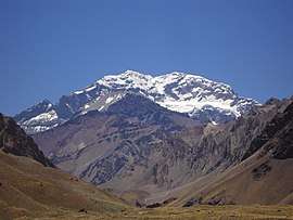 জাতীয় উদ্যানের প্রবেশপথ থেকে দৃশ্যমান অ্যাকনকাগুয়া। | |
| সর্বোচ্চ সীমা | |
| উচ্চতা | ৬,৯৬০.৮ মিটার (২২,৮৩৭ ফুট) [1] |
| সুপ্রত্যক্ষতা | ৬,৯৬০.৮ মিটার (২২,৮৩৭ ফুট) [1] Ranked 2nd |
| বিচ্ছিন্নতা | |
| তালিকাসমূহ | Seven Summits Country high point Ultra |
| নামকরণ | |
| উচ্চারণ | স্পেনীয়: [akoŋˈkaɣwa] /ˌækəŋˈkɑːɡwə/ or /ˌɑːkəŋˈkɑːɡwə/ |
| ভূগোল | |
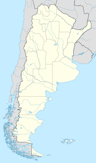 অ্যাকোনকাগুয়া Argentina | |
| অবস্থান | Mendoza Province, Argentina |
| প্রদেশ | AR-M |
| মূল পরিসীমা | Andes |
| আরোহণ | |
| প্রথম আরোহণ | 1897 by Matthias Zurbriggen (first recorded ascent)[2] |
| সহজ পথ | Scramble (North) |
অবস্থান
আন্দিজ পর্বতমালার মাঝে পশ্চিম আর্জেন্টিনার মেন্দোজা প্রভিন্সের রাজধানী মেন্দোজা থেকে ১১২ কিলোমিটার উত্তর-পশ্চিমে এটি অবস্থিত । স্যান জুয়ান প্রভিন্স থেকে এর চূড়ার দূরত্ব প্রায় ৫ কিলোমিটার এবং আর্জেন্টিনা-চিলির আন্তর্জাতিক সীমান্ত থেকে দূরত্ব প্রায় ১৫ কিলোমিটার।
অ্যাকনকাগুয়া পর্বত এবং এর সংলগ্ন এলাকা অ্যাকনকাগুয়া জাতীয় উদ্যানের অর্ন্তভুক্ত। এই পর্বতে একাধিক হিমবাহ বিদ্যামান রয়েছে। সবচেয়ে বড় হিমবাহ ভেনতিসকের হরকনেস ইনফেরিয়র প্রায় ১০ কিলোমিটার দীর্ঘ যা পর্বতটির দক্ষিণপাশ থেকে শুরু হয়ে ৩,৬০০ মিটার উচ্চতায় কনফ্লুয়েন্সিয়া ক্যাম্প পর্যন্ত বিস্তৃত।[3] অপর দুইটি বড় হিমবাহ হলো ভেনতিসকেরো দে লা ভাকাস সুর এবং গ্লাসিয়ার এসতে/ভেনতিসকেরা রেলিঞ্চোস; যাদের প্রতিটি প্রায় ৫ কিলোমিটার দীর্ঘ। তবে সবচেয়ে পরিচিত হিমবাহটি হলো উত্তর-পূর্বের পোলিশ গ্লেশিয়ার, কারণ এটি পর্বতটির চূড়ায় আরোহনের প্রচলিত পথ।
আরও দেখুন
তথ্যসূত্র
- "Informe científico que estudia el Aconcagua, el Coloso de América mide 6960,8 metros" [Scientific Report on Aconcagua, the Colossus of America measures 6960,8m] (Spanish ভাষায়)। Universidad Nacional de Cuyo। ২০১২। ৮ সেপ্টেম্বর ২০১২ তারিখে মূল থেকে আর্কাইভ করা। সংগ্রহের তারিখ সেপ্টেম্বর ৩, ২০১২।
- "There is no definitive proof that the ancient Incas actually climbed to the summit of the White Sentinel [Aconcagua], but there is considerable evidence that they did climb very high on the mountain. Signs of Inca ascents have been found on summits throughout the Andes, thus far the highest atop Llullaillaco, a ৬,৭২১-মিটার (২২,০৫১ ফু) mountain astride the Chilean-Argentine border in the Atacama region. On Aconcagua, the skeleton of a guanaco was found in 1947 along the ridge connecting the North Summit with the South Summit. It seems doubtful that a guanaco would climb that high on the mountain on his own. Furthermore, an Inca mummy has been found at 5400 m on the south west ridge of Aconcagua, near Cerro Piramidal" R. J. Secor, Aconcagua: A Climbing Guide, The Mountaineers, 1994, আইএসবিএন ০-৮৯৮৮৬-৪০৬-২, p. 13.
- Servei General d'Informacio de Muntanya, 2002, "Aconcagua 1:50,000 map", published by Cordee
বহি:সংযোগ
| উইকিমিডিয়া কমন্স সংক্রান্ত মিডিয়া রয়েছে: |
- "Aconcagua". SummitPost.org. http://www.summitpost.org/page/150197। সংগৃহীত হয়েছে 2010-10-26.
- Centro de Investigación en Medicina de Altura (CIMA) de Aconcagua is an international consortium of high altitude researchers and mountaineers interested in improving the safety of mountaineers on Aconcagua and enhancing our understanding of the pathology of high altitude illness.
- Daily time lapse animations of the Aconcagua base camp Webcam
- Highest peaks on peakware.com
- Interactive Satellite / Terrain Map, Photos, and Information on climbing Aconcagua
- Live webcam from Aconcagua base camp (December to March)
- Aconcagua: Everyman's Everest
- Mt. Aconcagua: information about location, routes, camps and weather